| | Thumbnail | | Creator | Date | Title / Author / Date / Location | Price | | | Description |
| 4706 | 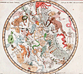 | Details | Fortin, J. | 1775 |
| Antique star chart of the Southern Hemisphere after Lacaille |
|
Fortin, J. |
|
| 1775 |
| LOC:13 |
| $280.00 | Fortin--J- | Antique-star-chart-of-the-Southern-Hemisphere-after-Lacaille | Fine decorative antique hand-colored engraved celestial star chart for the Southern Hemisphere from the Atlas Céleste de Flamstéed, updated and reduced by J. Fortin in 1776. This map of the Southern skies is based on Nicolas Louis de Lacaille’s star chart from 1754 in which Lacaille included 14 new constellations.
<br></br>
Lacaille sailed to South Africa in 1750 where he set up a small observatory at the Cape of Good Hope under the famous Table Mountain, which impressed him so much that he later named a constellation after it, Mensa. At the Cape in 1751 - 52 Lacaille observed the positions of nearly 10,000 stars. On his return to France in 1754, Lacaille presented a map of the southern skies to the French Royal Academy of Sciences which included 14 new constellations of his own invention. An engraved version of his celestial map was published in the Academy’s Mémoires in 1756 and Lacaille’s new constellations were rapidly accepted by other astronomers.
<br></br>
Flamsteed was born into a prosperous family & was largely self taught as he did not attend University due to poor health. He was appointed the first Astronomer Royal by King Charles II, with the Royal Observatory at Greenwich being built for him to continue his astronomical observations. Flamsteed's Celestial Atlas was first published ten years posthumously by his wife in 1729. It set the standard in professional astronomy for almost a century, with the positions of over 3,000 stars given more accurately than ever before.
<br></br>
French text for names of stars and constellations. Page 29. Lettered by Beauble' ; engraved by C.E. Voisard. |