| | Thumbnail | | Creator | Date | Title / Author / Date / Location | Price | | | Description |
| 1391 | 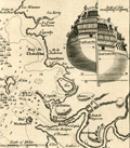 | Details | Gentlemans Magazine | 1758 |
| Antique Map of Basque Roads Anchorage near Rochefort, France |
|
Gentlemans Magazine |
|
| 1758 |
| LOC:7 |
| $125.00 | Gentlemans-Magazine | Antique-Map-of-Basque-Roads-Anchorage-near-Rochefort--France | Neat antique map of Basque Road anchorage related to the failed 1757 British surprise attack of the port of Rochefort, France, along the Charente River. Locations shown include the Isle of Aix, Isle Madame, "Chatalilon" (Chatelaillon) , Fort de la Point, and Fort Lupin.
<br></br>
With a profile view of Fort Fouras with its 17th century fortifications. Although the French were taken by surprise, a bombardment by the British on Fort Fouras was called off when the water off the Fort was discovered to be too shallow. Inset stern view of a Brtish triple-decked ship-of-the line was included to support the discussion in text about the water depth at Fort Fouras.
<br></br>
This fine original copper-engraved map was take from Gentleman's Magazine and Historical Chronicle, Vol 28. |
| 6630 | 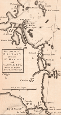 | Details | Gentlemans Magazine | 1758 |
| Coast of Britany Between St. Malos and Cancale Bay Where the English Army Landed June 1758 |
|
Gentlemans Magazine |
|
| 1758 |
| LOC:41 |
| $250.00 | Gentlemans-Magazine | Coast-of-Britany-Between-St--Malos-and-Cancale-Bay-Where-the-English-Army-Landed-June-1758 | Coastal chart of Britany (Brittany) between the ports of St. Malo France and Cancale, centered on St. Malo. The chart was published in Gentlemen's Magazine June, 1758. St. Malo is said to have been the birthplace of Henri Michelot, French Galley Pilot and cartographer.
<br><br>
Map with north at the right Verso is blank. |
| 1172 | 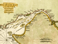 | Details | Gentlemans Magazine | 1779 |
| Revolutionary War era chart of Delaware Bay and River |
|
Gentlemans Magazine |
|
| 1779 |
| LOC:0 |
| $0.00 | Gentlemans-Magazine | Revolutionary-War-era-chart-of-Delaware-Bay-and-River | SOLD
<br></br>
Small antique chart of Delaware Bay and River. Derived from the larger chart of Delaware Bay and River up to Philadelphia, Pennsylvania by Joshua Fisher (1707-1783) in 1776. Shows the location of a Pilot's Town near Cape Henlopen. Identifies the ship channels from Cape May and Cape James up the Delaware River past Salem Mass., Wilmington, Newcastle, and Chester to the small town of Philadelphia, Pennsylvania. Key features include Mud Island, the Schuylkill River, Stony Point, Egg Island Flats, Fortescue's Island, Cold Spring Inlet, Turtle Gut Inlet, and Rehoboth Bay. The mouths of numerous creeks are named including Clark's Ditch, Motherkiln Creek, and Nantuxet Creek.
<br></br>
Published in the "Gentleman's Magazine", July 1779, volume 49, page 369.
<br></br>
Joshua Fisher's early chart of Delaware Bay from the Sea-Coast to Reedy-Island was published during the French & Indian War, and was immediately suppressed by the Assembly, fearing that its falling into enemy hands would make Philadelphia a target of the French navy. Fisher's chart showed the lower part of the bay and was intended to be used as a navigational aid for ships sailing toward Philadelphia. In 1775, Fisher produced an expanded chart that showed the bay and the Delaware River to just beyond Philadelphia. This was the most important map of the bay and river in the 18th century. |