| | Thumbnail | | Creator | Date | Title / Author / Date / Location | Price | | | Description |
| 5258 | 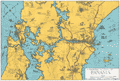 | Details | Goodrich, James J. | 1930 |
| Unrecorded Panoramic Pictorial Map of Panama |
|
Goodrich, James J. |
|
| 1930 |
| LOC:77 |
| $275.00 | Goodrich--James-J- | Unrecorded-Panoramic-Pictorial-Map-of-Panama | Unrecorded pictorial map of Panama by Corporal James J. Goodrich, 11th Engineers ca. 1930. Adorned with numerous idiosyncratic illustrations including at upper right a drawing of a panther labeled "Black Cats." Many illustrations of military aircraft and naval vessels. Dotted line north of the Panama Canal shows a "proposed highway across the isthmus" beginning at the Madden Dam, completed in 1935, and terminating at Colon on the Pacific Ocean.
<br></br>
The 11th Engineer battalion was activated on the 20th of November, 1920 in the Panama Canal Zone. The 11th engineers conducted numerous engineer missions over rugged terrain and through dense jungle. It was in Panama that the 11th adopted for its crest the Panama Black Panther and assumed the nickname "Jungle Cats." The 11th Engineers were relieved of their assignment to the Panama Canal Division in April, 1932. |
| 5341 | 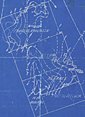 | Details | Goodrich, James J. | 1930 |
| Cyanotype map of oilfields north of Round Rock Austin Texas |
|
Goodrich, James J. |
|
| 1930 |
| LOC:88 |
| $0.00 | Goodrich--James-J- | Cyanotype-map-of-oilfields-north-of-Round-Rock-Austin-Texas | SOLD
<br></br>
Original cyanotype (blueprint) map of "massive beds of buda limestone" and associated oil wells drilled in the area between 1915 and 1925. The blueprint map "Reconnaissance Map of Part of Williamson, Texas" covers an area extending north from Round Rock, Texas, terminating at Georgetown, Texas a distance of approximately 8 miles.
<br></br>
Owners of the tracts of land shown on this map include: Francis A, Hudson, B. C. Low, A. L. Eaves, N. B. Anderson, and Thomas Glasscock.
<br></br>
From 1854 to 1882, the Texas state legislature gave each railroad company 16 sections of land out of its public domain for every mile of railroad constructed and put into use anywhere in the state. The map shows the lines for two railways: the International and Great Northern Railroad (I. & G. N. R. R.) and the Missouri, Kansas, and Texas Railroad (M. K. & T. R. R. ) which encircle the area covered in this map.
<br></br>
Signed within by H. B. Goodrich, Petroleum Geologist. Tulsa, Oklahoma. June 18, 1930. |