| | Thumbnail | | Creator | Date | Title / Author / Date / Location | Price | | | Description |
| 368 | 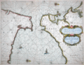 | Details | Goos, Pieter | 1664 |
| Cuft van Hispagnien vande Rivier Sivilien |
|
Goos, Pieter |
|
| 1664 |
| LOC:8 |
| $1,450.00 | Goos--Pieter | Cuft-van-Hispagnien-vande-Rivier-Sivilien | Attractive and desirable small-scale antique nautical chart covers the Atlantic approaches to the Strait of Gibraltar with Cadiz, Spain, Algeciras ("Out Gibralter"), Sanlucar de Barrameda , Xeres, Rota, Cape Trafalgar, and the Guadalquivir River to just past the small stream of Brazo de la Torre. Inside the strait and in the Mediterranean are Tangier, Ceuta, Tetuan, and Penon de Velez on the north coast of Africa. On the south coast of Spain Gibraltar, Algeciras, Tarifa, Marbella, and Malaga are featured. <BR> </BR>
A fine antique chart of the historically important area surrounding the Strait of Gibraltar and Cadiz, Spain. With an elaborate strapwork cartouche, two compass roses, and depictions of a galley and a square-rigged sailing vessel, the two predominant sea-going vessels of that era. Produced by Dutch cartographer Pieter Goos in Amsterdam in 1664. North oriented to the right. Plate number 3. <BR> </BR> |
| 367 | 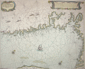 | Details | Goos, Pieter | 1664 |
| Cuften van Noorwegen |
|
Goos, Pieter |
|
| 1664 |
| LOC:0 |
| $0.00 | Goos--Pieter | Cuften-van-Noorwegen | SOLD<br></br>
Beautiful antique engraved chart of the Skagerrak with Swedish and Norwegian coast and fjords centered on Oslo. Produced by Dutch cartographer Pieter Goos in Amsterdam in 1664. <BR> </BR>
Primary coverage includes the south coast of Norway from "Der Neus" east of Kristiansand, past Oslo fjord to Pater Nosterskärgårdens naturreservat on the southwest coast of Sweden. Slight coverage of northwest Jutland includes Skagen. Place names on this antique nautical chart are in Dutch so matching place names to their current equivalent is challenging: Anfloo = Oslo; Tonfberger = Tonsberg; Laerwyck = Larvik; Schagen = Skagen; Trom = Tromoy; Vlecker = Flekkerøy. Most other place names difficult (for me) to identify. Other unknown cities include Coperwyck, Akershuys, De Buy, Hefnes . Plate number 8.<BR> </BR>
Probably derived from the earlier work by Willem Janszoon Blaeu in 1619. |
| 556 | 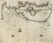 | Details | Goos, Pieter | 1667 |
| Pascaarte van Engelant |
|
Goos, Pieter |
|
| 1667 |
| LOC:57 |
| $1,300.00 | Goos--Pieter | Pascaarte-van-Engelant | Lovely copperplate engraved sea chart of the East Coast of England with the Thames estuary by Dutch cartographer Pieter Goos. Inset of the Thames River including London. The date of publication was just one year after the great fire that destroyed London in 1666. Place names and feature descriptions are in Dutch.<br><br/>
From Pieter Goos' De Zee-Atlas, Ofte Water-Weereld, Waer in vertoont werden alle de Zee-Kusten Van het bekende des Aerd-Bodems. 1667. |
| 2577 | 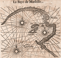 | Details | Goos, Pieter | 1669 |
| 17th century woodblock chart of Marseilles, France |
|
Goos, Pieter |
|
| 1669 |
| LOC:77 |
| $185.00 | Goos--Pieter | 17th-century-woodblock-chart-of-Marseilles--France | Two woodblock charts (verso and recto) of the Bay of Marseille, France and of the coast and islands of the Bay of Hyeres: Porquerolles, Port Cros, Ile du Levant. Scarce.
<br></br>
Produced by Dutch cartographer Pieter Goos from Amsterdam in 1669. |