| | Thumbnail | | Creator | Date | Title / Author / Date / Location | Price | | | Description |
| 5357 | 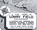 | Details | Grimes, George | 1944 |
| Pictorial map of Lowry Field Denver Colorado |
|
Grimes, George |
|
| 1944 |
| LOC:77 |
| $275.00 | Grimes--George | Pictorial-map-of-Lowry-Field-Denver-Colorado | A very scarce pictorial map of Lowry Field, at the eastern edge of Denver, Colorado, from the first issue of the Lowry Field Information Handbook [1] in November, 1944. Lowry field was activated in February, 1938 as the site of the Army Air Forces Training Command [2]. From the 1980’s, Lowry Air Force Base was one of Colorado’s largest employers. Lowry AFB employed nearly 10,000 military and civilian men and women, providing an economic impact annually approaching $1 billion [3].
<br></br>
<div class="indenttextblocksingle">
[1] Earliest publication was November, 1944 with a later edition of February, 1945. On the later map a telephone icon is added and locations of the telephone shelter house and telephone lounges are colored orange.<br>
[2] Information Handbook Lowry Field (AAF Training Command). Mountain States Telephone and Telegraph Company. Denver. 1944. Online.<br>
[3] https://wingsmuseum.org/about/history/. Online
</div> |