| | Thumbnail | | Creator | Date | Title / Author / Date / Location | Price | | | Description |
| 1053 | 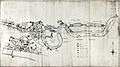 | Details | H.M. Board of Customs and Excise | 1883 |
| Manuscript Map of Thames Docks, Sufferance Wharves, and Uptown Warehouses |
|
H.M. Board of Customs and Excise |
|
| 1883 |
| LOC:0 |
| $0.00 | H-M--Board-of-Customs-and-Excise | Manuscript-Map-of-Thames-Docks--Sufferance-Wharves--and-Uptown-Warehouses | SOLD
<br></br>
Fascinating 19th century pen and ink manuscript map of the area now referred to as the <b>London Docklands</b>, a center for redevelopment and urban renewal. Includes the location of the recently constructed <b>Canary Wharf</b> business district in the bend of the Thames River called the Isle of Dogs (once referred to as Stepney Marsh). This antique manuscript map on linen covers the late 19th century quays, sufferage wharves, docks, and uptown warehouses that existed about 1883. Coverage of the upper map along the Thames River extends from above Southwark Bridge, past London Bridge and the Tower of London, and terminates at the entrance to the Royal Albert Dock about 11 miles south of London. An inset detailed map covers the City of London and Tower Hill districts to the east end of the London Docks.
<br></br>
Date of the map of 1883 is an estimate based on the fact that the Royal Albert Dock, which opened in 1880, is shown while the Tower Bridge, begun in 1886, is not shown. |