| | Thumbnail | | Creator | Date | Title / Author / Date / Location | Price | | | Description |
| 7987 | 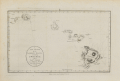 | Details | Harrison, John | 1784 |
| A New Chart of the Sandwich Islands including oWhyhee Hawaii |
|
Harrison, John |
|
| 1784 |
| LOC:130 |
| $1,100.00 | Harrison--John | A-New-Chart-of-the-Sandwich-Islands-including-oWhyhee-Hawaii | Engraved chart of the Hawaiian Islands issued shortly after the publication of the official account of Captain Cook’s third voyage (James King; June, 1784). This chart was published one month later in London by Harrison & Co., on July 1, 1784. It traces the routes of Cook’s ships Resolution and Discovery through the Hawaiian archipelago and highlights “oWhyhee” (Hawaiʻi), where Cook met his death in February 1779.
<br><br>
Based closely on Henry Roberts’ official chart but without the inset of Kealakekua Bay, Harrison’s version was created for a popular audience eager for news of the famous explorer’s final journey.
The map offers one of the earliest separately issued depictions of the Hawaiian Islands, capturing the moment when they first entered European geographic consciousness.
<br><br>
Printed from a finely engraved copper plate, the chart combines geographic accuracy with contemporary drama, naming each island and noting Cook’s fatal landing. Examples of this edition are far scarcer than those bound in the official voyage atlas, making it a sought-after piece for collectors of Pacific exploration and early Hawaiian cartography.
<br><br> |