| | Thumbnail | | Creator | Date | Title / Author / Date / Location | Price | | | Description |
| 1006 |  | Details | Holden, George | 1843 |
| Approaches to Liverpool 1843 |
|
Holden, George |
|
| 1843 |
| LOC:0 |
| $0.00 | Holden--George | Approaches-to-Liverpool-1843 | SOLD
<br></br>
Scarce, well illustrated, and very 'nautical' chart of Liverpool Bay and the Mersey estuary with the entrance to the Mersey River. An unusual, information-dense navigational chart from 1843 of the Mersey Estuary packed with details on buoys, lights, channels, range markers, soundings and sailing directions. The chart is surrounded by enlarged profile views of lights, lightships, and range marks to aid in their identification. Working clockwise from top right these objects include: Bootle Marks, Rock Light, Leasowe Light, N.W. Formby, N.W. Lightship, Formby Lightship, Crosby Lightship, Bell Beacon, Hoylake lower and upper light, Bidston Light, New C. Mark, Crosby Light, Point of Ayre Light, and S.E. Mark.
<br></br>
Verso with a view attributed to B.C. Watts showing the arrangement of general communications signals about the lighthouses, made by hoisting flags, pendants, or balls to poles each with a specific purpose.
<br></br> |
| 732 | 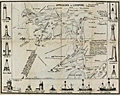 | Details | Holden, George | 1850 |
| Approaches to Liverpool 1850 |
|
Holden, George |
|
| 1850 |
| LOC:0 |
| $0.00 | Holden--George | Approaches-to-Liverpool-1850 | SOLD<br></br>Scarce, well illustrated, and very 'nautical' chart of Liverpool Bay and the Mersey estuary with the entrance to the Mersey River. An unusual, information-dense navigational chart from 1850 of the Mersey Estuary packed with details on buoys, lights, channels, range markers, soundings and sailing directions. The chart is surrounded by enlarged profile views of lights, lightships, and range marks to aid in their identification. Working clockwise from top right these objects include: Bootle Marks, Rock Light, Leasowe Light, N.W. Formby, N.W. Lightship, Formby Lightship, Crosby Lightship, Bell Beacon, Hoylake lower and upper light, Bidston Light, New C. Mark, Crosby Light, Point of Ayre Light, and S.E. Mark.
<br></br>
Verso with a view attributed to B.C. Watts showing the arrangement of general communications signals about the lighthouses, made by hoisting flags, pendants, or balls to poles each with a specific purpose.
<br></br>
The above chart was issued with and folds into "Holden's Original Pocket Almanac and Tide Table, 1851" (3" x 5") included in the price. Along with tide tables, the Almanack includes information on distances to places on the river, life-boat stations, pilot-boats, widths of dock entrances and several dozen more types of information that would be useful to mariners or ship-owners.
<br></br>
In worn, blue paper covers, with intact and tight pages. The chart is loose but in good condition. Engraved and printed by J.B. Leatherbarrow, South John Street, Liverpool. Sold by Thomas Kaye, Castle-street. |