| | Thumbnail | | Creator | Date | Title / Author / Date / Location | Price | | | Description |
| 7984 | 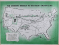 | Details | Howells, Rulon S. | 1961 |
| Map of The Mormon Exodus to the Rocky Mountains |
|
Howells, Rulon S. |
|
| 1961 |
| LOC: |
| $300.00 | Howells--Rulon-S- | Map-of-The-Mormon-Exodus-to-the-Rocky-Mountains | Scarce mid-20th-century educational wall poster depicts the westward migration of the Mormon pioneers from the eastern United States to the Great Salt Lake Valley. The map traces multiple overland and sea routes—from early settlements in New York, Ohio, and Illinois across Iowa, Nebraska, and Wyoming to Utah—with fine line work and green-toned shading that visually emphasizes the journey’s progression.
<br><br>
Illustrations along the route show covered wagons, handcarts, and pioneer figures, while smaller vignettes depict scenes such as the Mormon Battalion’s march and seaborne emigrant routes from Europe. At lower left, a narrative block summarizes the migration’s history, noting Brigham Young’s leadership and the founding of the Great Salt Lake settlement in 1847.
<br><br>
Printed in green and black on white stock, the map carries the imprint: “A Teaching Aid – The Mormon Story – Teaching Aids, Inc., Highland Park, Illinois.” This poster was likely used in classrooms and religious education settings during the 1960s, part of a broader trend toward illustrated historical maps as visual teaching tools. An attractive and informative example of mid-century American educational cartography.
<br><br>
Published by Bookcraft, Inc, 1961. |