| | Thumbnail | | Creator | Date | Title / Author / Date / Location | Price | | | Description |
| 3693 | 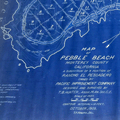 | Details | Hunter, T.B. | 1909 |
| Large antique blueprinted map of Pebble Beach, California |
|
Hunter, T.B. |
|
| 1909 |
| LOC:1408 |
| $1,800.00 | Hunter--T-B- | Large-antique-blueprinted-map-of-Pebble-Beach--California | Fine large rolled 5' original antique cyanotype (blueprint) map (20 sq. ft.) of Pebble Beach, CA made in 1909, almost ten years before the opening of the famed Pebble Beach golf course. The earliest reasonably obtainable and the largest cyanotype cadastral map of Pebble Beach, CA.
<br></br>
Ironically, on this map the area now partly occupied by the golf course is marked "Reserved for Public Use". Pebble Beach Lodge is shown centered within Lot 123, a parcel of 9.487 acres. Locations that are shown but not named include Arrowhead Point, Pescadero Canyon, and Stillwater Cove.
<br></br>
Data for each lot include the lot number, metes and bounds (bearing and length of all lines bisecting each physical property marker stake), and acreage.
<br></br>
Includes Seventeen-Mile Drive and Carmel Bay. Monterey County. Shows topography with contour intervals of 10 feet.
<br></br>
Surveyed by T.B. Hunter, C.E. and drawn by T.F. Rogers.
<br></br>
North is oriented to upper right.
<br></br>
(Note: Yellow straight-edge rules shown are 48" long.) |