| | Thumbnail | | Creator | Date | Title / Author / Date / Location | Price | | | Description |
| 891 | 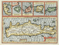 | Details | Jansson, Jan | 1630 |
| Antique map of Crete, Corfu, Zante, Milo, Naxos, Scarpanto |
|
Jansson, Jan |
|
| 1630 |
| LOC:2 |
| $315.00 | Jansson--Jan | Antique-map-of-Crete--Corfu--Zante--Milo--Naxos--Scarpanto | Antique map of several of the <b>Cycladic Greek islands</b> plus Corfu. A reduced-size copperplate engraving of Mercator's map of Crete ( "Candia" ) with inset maps above for the Greek isles of Corfu, Zante, Milos, Naxos ( "Nicsia" ), and Scarpanto.
<br></br<
Published 1630 by Jan Jansson from Amsterdam for Gerard Mercator's "Atlas Minor". Latin text on verso. |
| 654 | 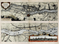 | Details | Jansson, Jan | 1648 |
| Elbe River with Hamburg Germany |
|
Jansson, Jan |
|
| 1648 |
| LOC:89 |
| $600.00 | Jansson--Jan | Elbe-River-with-Hamburg-Germany | Beautiful, hand-colored map of the Elbe ( Albis ) River by Jan Jansson (Johanne Jansonnious) from 1648. Attractive inset profile of Hamburg, Germany "Emporium Hamburgum" with 17 referenced buildings tied to explanatory notes. Traces the course of the Elbe River from "De Noordt Zee" past Brokdorf, Gluckstadt, Stade, Buxtehude, past Hamburg, and ends at Geesthact. Numerous towns, churches, windmills and other structure are noted by name. Latin text. Published from Amsterdam. |
| 600 | 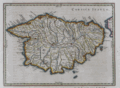 | Details | Jansson, Jan | 1657 |
| Het Eylandt Corsica |
|
Jansson, Jan |
|
| 1657 |
| LOC:8 |
| $0.00 | Jansson--Jan | Het-Eylandt-Corsica | SOLD<br><br>
Antique Dutch map of the French island of Corsica ( Corse ), in the Mediterranean Sea from ca. 1657 by Jan Jansson. Jansson (1588-1664) was a Dutch publisher and map maker from Amsterdam.
<br></br>
This nautical map is an original antique, over 350 years old and is oriented with North to the left. Prominent coastal details that are featured include: San Bonifacio strait, Golfo S. Fiorenzo, Golfo de Genarca, Golfo Aiazzo, Gollfo de Talabo, and at the far West, Capo Corsa.
<br></br>
On a folio-sized page with Dutch text on both the recto and verso related to the geography of that island.
<br></br>
Page 21. |
| 4755 | 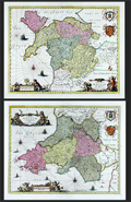 | Details | Jansson, Jan | 1720 |
| Fine pair (2) of antique maps of North Wales and South Wales. |
|
Jansson, Jan |
|
| 1720 |
| LOC:64 |
| $1,100.00 | Jansson--Jan | Fine-pair-(2)-of-antique-maps-of-North-Wales-and-South-Wales- | Pair of beautiful antique maps of North and South Wales in the United Kingdom ca. 1720. Fine condition. Both maps are filled with charming pictorial topography describing forests, cities, and mountains. Published in Amsterdam by Pieter Schenk and Gerard Valk after Joannes Janssonius (Jan Jansson).
<br></br>
Locations within Wales include Glamorgan, Carmarthen, Pembroke, Brecon, Cardigan, Radnor in South Wales and Snowdown Hill (Snowdon) in North Wales, the highest mountain in the country. Both maps are adorned with superb engraved aquatic cartouches adorned with putti, coats of arms and sailing ships. Blank verso. Attribution at bottom to Shenk and Valk, Amsterdam, publishers. |