| | Thumbnail | | Creator | Date | Title / Author / Date / Location | Price | | | Description |
| 6326 | 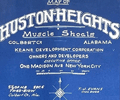 | Details | Keane Development Corporation | 1933 |
| Blueprint plat map for Huston Heights Muscle Shoals, Alabama |
|
Keane Development Corporation |
|
| 1933 |
| LOC:53 |
| $250.00 | Keane-Development-Corporation | Blueprint-plat-map-for-Huston-Heights-Muscle-Shoals--Alabama | Rare unrecorded cyanotype (blueprint) plat map of the Huston Heights development near <b>Muscle Shoals</b>, Alabama which was incorporated in 1923.</b> Inset at upper left is a fine context map of the Tri-cities area of Florence, Sheffield, and Muscle Shoals compiled by T.J. Evans showing the locations of the Huston Heights development. Features the Wilson Dam on the Tennessee River and two nitrate plants. Dated within at February, 1933.
<br></br>
The plat encompasses an area in Muscles Shoals bounded by and including Ford Highway, Washington Drive, Henry Street and Sheridan Drive. |