| | Thumbnail | | Creator | Date | Title / Author / Date / Location | Price | | | Description |
| 5480 | 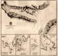 | Details | King, Peter Parker | 1840 |
| Rare charts of Smyth and Fury Harbor Magellan Strait Chile |
|
King, Peter Parker |
|
| 1840 |
| LOC:89 |
| $0.00 | King--Peter-Parker | Rare-charts-of-Smyth-and-Fury-Harbor-Magellan-Strait-Chile | SOLD<br><br>Very rare engraved chart of Smyth Harbor, Fury Harbor and three other harbors of refuge, all along the Barbara Channel, one of three channels that connects the <strong>Strait of Magellan</strong> to the Pacific Ocean [1]. By Captain Phillip Parker King R.N. and printed just ten years after King surveyed the area aboard the Adventure, a stout ship of 330 tons.
Chart # 1306. London. 1840.
<br></br>
King named Smyth Harbor after Captain (later Admiral) William Henry Smyth who had commanded the Adventure before King and who was an early member of a number of learned societies, well known for his hydrographic charts, for his astronomical work, and for a wide range of publications in varied fields.
<div class="indenttextblocksingle">
"On the south side of Mount Maxwell is Smyth Inlet, which contains anchorage on the north shore, particularly one in Earle Cove; but in the centre the water is deep, and on that account, it is not an inviting place for a ship. [2]"</div>
<br>
Scale below graduated in "Nautic Miles". Rhumb lines subtly visible only near margins. Admiralty, December 24, 1840. R.B. Bate Agent for Admiralty Charts 21 Poultry.
<br></br>
[1] The other two channels connecting Magellan Strait to the Pacific are Abra Channel and Magdalena Channel. </br>
[2] King, P. P. Narrative of the surveying voyages of His Majesty's Ships Adventure and Beagle between the years 1826 and 1836, describing their examination of the southern shores of South America, and the Beagle's circumnavigation of the globe. Proceedings of the first expedition, 1826-30, under the command of Captain P. Parker King, R.N., F.R.S. London: Henry Colburn. 1839. [Online]. |