| | Thumbnail | | Creator | Date | Title / Author / Date / Location | Price | | | Description |
| 850 | 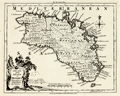 | Details | Kitchin, Thomas | 1756 |
| Antique Map of the Balearic Island of Menorca or Minorca |
|
Kitchin, Thomas |
|
| 1756 |
| LOC:0 |
| $0.00 | Kitchin--Thomas | Antique-Map-of-the-Balearic-Island-of-Menorca-or-Minorca | SOLD<br></br>
Detailed antique map of the island of Menorca ("Minorca"), one of Spain's Balearic Islands in the Mediterranean Sea. Some of the features that are noted on the map include: Governor of the Castles House, a Signal House, Mahon Harbor, Marlborough Redoubt, and St. Stephen's Cove.
<br></br>
From the London Magazine of March 1756 just a few months before the Battle of Minorca fought between the French and British fleets on May 20, 1756. The French won the battle. British Vice-Admiral John Byng had orders to relieve the garrison protecting Fort St. Philip in Port Mahon, but was court-martialed and later executed for failing to do enough to try to relieve the fort.
<br></br>
With text detached from the map for "A Description of the Island of Minorca" containing brief details of the history, geography, and inhabitants of the island. Published by R. Baldwin Pater Noster Row, London. 1756. Scale is 69 British Statute Miles to one degree of latitude. |