| | Thumbnail | | Creator | Date | Title / Author / Date / Location | Price | | | Description |
| 615 | 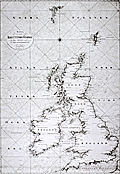 | Details | Klint, Gustaf | 1803 |
| Scarce Swedish chart of the British Isles by Admiral Gustaf Klint |
|
Klint, Gustaf |
|
| 1803 |
| LOC:0 |
| $1,500.00 | Klint--Gustaf | Scarce-Swedish-chart-of-the-British-Isles-by-Admiral-Gustaf-Klint | Original antique nautical chart of the British Isles from 1803 by Admiral Gustaf Klint (1771 - 1840) of the Swedish Royal Navy. This scarce antique "Karta ofver Brittiske Öarne" covers the Shetland, Faroe, and Orkney Islands, England, Scotland, Wales, and Ireland to Cornwall and the western coast of France below Calais. The engraving on this chart is quite exceptional and with added color could be a startling conversation piece. <br></br>
Charts of the British Isles by Admiral Klint are scarce as most of his hydrographic efforts were spent on his native land, Sweden- principally the Gulf of Bothnia. Klint is also known for his sailing directions of the Baltic Sea, Gulf of Finland, and Gulf of Bothnia, published posthumously. Number 19. <sup>1</sup>
Swedish text.<br></br>
<sup>1</sup> Dawson, L.S. ( Commander ). "Memoirs of Hydrography including brief biographies of the Principal Officers who have served in H.M. Naval Surveying Services between the years 1750 and 1885". Part II. 1885. [ http://books.google.com/books?id=3SwBAAAAQAAJ&dq=gustaf+klint+admiral&source=gbs_navlinks_s ] |