| | Thumbnail | | Creator | Date | Title / Author / Date / Location | Price | | | Description |
| 7974 | 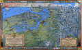 | Details | Kroll Map Company | 1944 |
| Evergreen Playground View of Pacific Northwest First State |
|
Kroll Map Company |
|
| 1944 |
| LOC:130 |
| $250.00 | Kroll-Map-Company | Evergreen-Playground-View-of-Pacific-Northwest-First-State | This pictorial map, titled The Evergreen Playground, (first state with the Tacoma Narrows Bridge lacking a deck) was published in 1944 by the Kroll Map Company of Seattle. It presents a detailed bird’s-eye view of western Washington, extending from Olympia and Tacoma northward through Seattle and Everett to Bellingham and Vancouver, B.C., and eastward to the Cascade Mountains. The map highlights major highways, railways, ferry routes, and points of interest, emphasizing the transportation network and recreational attractions of the Pacific Northwest at mid-century. Drawn by Ed Poland.
<br><br>
Insets along the borders depict regional scenery, industry, and Native American–inspired motifs. The lower right legend identifies the “Unequaled Transportation Facilities” that connect the area by train, highway, and ferry service. The title panel describes the region as unique in North America for combining sea, forest, and mountain environments within a compact area. Printed in full color with topographic shading and decorative borders, this map reflects the Kroll Company’s skill in cartographic illustration and mid-20th-century regional promotion.
<br><br>
Ed (Edwin) Poland was a long-time chief cartographer at the Seattle-based Kroll Map Company, active from at least the 1930s through the postwar era. Poland’s work for Kroll is characterized by dense place-name coverage, promotional vignettes, and clear drafting that made the firm’s Pacific Northwest maps popular for decades. |