| | Thumbnail | | Creator | Date | Title / Author / Date / Location | Price | | | Description |
| 846 | 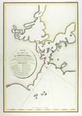 | Details | La Perouse, Jean François Galaup | 1797 |
| Antique French Chart of San Francisco Bay, California |
|
La Perouse, Jean François Galaup |
|
| 1797 |
| LOC:0 |
| $0.00 | La-Perouse--Jean-François-Galaup | Antique-French-Chart-of-San-Francisco-Bay--California | SOLD<br></br>
This antique French chart is the earliest available chart (1797) for collectors of the San Francisco Bay area, in California. The map was produced by Jean François Galaup la Perouse after a 10 day exploration of the San Francisco area in 1786 and published posthumously in 1797. Earlier manuscript charts do exist, by Cañizares in 1776 and 1781, but these are extremely rare and generally not available to collectors.
<br></br>
A legend with 20 items is keyed to locations on the map including "Presidio de San Francisco", Mission de San Francisco", "Ile de Alcatraces" ( Alcatraz Island ), and "Pte. de Reyes". Depth soundings and anchorages are marked generally in the lower bay only.
<br></br>
As a French explorer and naval officer la Perouse (1741-1788?) was tasked by King Louis XVI of France with completing the Pacific exploration begun by British Captain James Cook. Aboard the ships Astrolabe and Boussole, la Perouse and his crew mapped the west coast of North America and Alaska in 1786 and visited Easter Island and the Sandwich Islands ( Hawaii ). After reaching Australia's Botany Bay in 1788 his ships were lost at sea while searching for the Solomon Islands.
<br></br>
This map is from the French edition of the "Atlas du voyage de La Perouse". L. Aubert scripsit. Plate 33. |
| 721 | 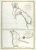 | Details | La Perouse, Jean François Galaup | 1797 |
| Antique 1782 Plan of San Diego, California |
|
La Perouse, Jean François Galaup |
|
| 1797 |
| LOC:63 |
| $800.00 | La-Perouse--Jean-François-Galaup | Antique-1782-Plan-of-San-Diego--California | Two very attractive engraved antique nautical charts on one page of the harbors of <b>San Diego</b>, California (upper half) and San Blas, Mexico in Nayarit State. Locations around San Diego, California that are noted on the chart include: the Presidio de St. Diego, the 'faux port', Pointe des Morts, Rancherie de las Choyas, Pointe St. Augustin, Rancherie ou Village d'Indiens nomme de la Pointe, Pointe St. Joseph, Pointe St. Michel, Petite Port de St Jean, Pointe Guizarros, and Pointe de la Colline. Numerous soundings are included with descriptions of the composition of the sea floor on the approaches to and bottom of the San Diego Bay.
<br></br>
These two charts by Jean-Francois de la Perouse are based on surveys by Juan Pantoja, a captain of the Manila trade for Spain. Derived from Pantoja's manuscript, the charts were published posthumously in the "Atlas du Voyage de la Perouse 1785-1788". Plate 35.
<br></br>
San Blas was used by Spain's Navy as a naval base beginning in 1768 and it served for several decades as a base of operations for Spanish expeditions to the Pacific Northwest. For about twenty years in the late 18th century, San Blas was one of the busiest ports on the Pacific coast of the Americas, rivaling Acapulco. L. Aubert, scripsit.
<br></br>
As a French explorer and naval officer la Perouse (1741-1788?) was tasked by King Louis XVI of France with completing the Pacific exploration begun by British Captain James Cook. Aboard the ships Astrolabe and Boussole, la Perouse and his crew mapped the west coast of North America and Alaska in 1786 and visited Easter Island and the Sandwich Islands ( Hawaii ). After reaching Australia's Botany Bay in 1788 his ships were lost at sea while searching for the Solomon Islands. |
| 3587 | 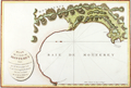 | Details | La Perouse, Jean François Galaup | 1797 |
| Beautiful Antique Chart of Monterey Bay and Carmel Bay, California |
|
La Perouse, Jean François Galaup |
|
| 1797 |
| LOC:10 |
| $950.00 | La-Perouse--Jean-François-Galaup | Beautiful-Antique-Chart-of-Monterey-Bay-and-Carmel-Bay--California | First French edition of this original antique early plan of Monterey Bay, Carmel, and Carmel Bay in California. This map is the earliest obtainable map of the Monterey and Carmel region.
<br></br>
Because this chart is the only one of Perouse's charts based on his own exploration some dealers consider this map to be a foundational map for all collectors of 18th century California cartography.
<br></br>
The fine hand-colored chart shows the very small town of Carmel with the Mission de St. Charles, and the Presidio at a distance. The map makes it possible to understand how the development of local transportation routes was impacted by the area's geography. Locates an anchorage (mouillage"), Pointe du Nouvel-an (New Year Point near Santa Cruz) and the Montagnes de St. Lucie. Rhumb lines in the bay with north oriented to the left. A scarce map of the area.
<br></br>
As a French explorer and naval officer la Perouse (1741-1788?) was tasked by King Louis XVI of France with completing the Pacific exploration begun by British Captain James Cook. Aboard the ships Astrolabe and Boussole, la Perouse and his crew mapped the west coast of North America and Alaska in 1786 and visited Easter Island and the Sandwich Islands ( Hawaii ). After reaching Australia's Botany Bay in 1788 his ships were lost at sea while searching for the Solomon Islands.
<br></br>
This map is from the French edition of the "Atlas du voyage de La Perouse". L. Aubert scripsit. Plate 34. |
| 3616 | 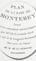 | Details | La Perouse, Jean François Galaup | 1797 |
| Earliest obtainable map of the Monterey and Carmel, California region. |
|
La Perouse, Jean François Galaup |
|
| 1797 |
| LOC:10 |
| $550.00 | La-Perouse--Jean-François-Galaup | Earliest-obtainable-map-of-the-Monterey-and-Carmel--California-region- | The first French edition of the antique early plan of Monterey Bay, Carmel, and Carmel Bay in California is an uncolored and historically significant chart. It is the only chart of La Pérouse's based on his own exploration, making it a foundational map for collectors of 18th-century California cartography. This chart represents the earliest obtainable map of the Monterey and Carmel region.
<br><br>
The hand-colored chart accurately portrays the small town of Carmel, featuring the Mission de St. Charles and the Presidio at a distance. The map provides insight into how the area's geography impacted the development of local transportation routes. It locates an anchorage (mouillage), Pointe du Nouvel-an (New Year Point near Santa Cruz), and the Montagnes de St. Lucie. The bay's rhumb lines are oriented with north to the left, adding to the rarity of the map.
<br><br>
This map is part of the French edition of the "Atlas du voyage de La Perouse," with L. Aubert as the engraver. It appears as Plate 34 within the atlas. Collectors and historians alike treasure this map as a crucial piece of 18th-century California cartography and a testament to La Pérouse's exploration of the Pacific. |
| 2548 | 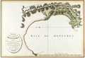 | Details | La Perouse, Jean François Galaup | 1797 |
| Antique French Chart of Monterey Bay and Carmel Bay, California |
|
La Perouse, Jean François Galaup |
|
| 1797 |
| LOC:0 |
| $0.00 | La-Perouse--Jean-François-Galaup | Antique-French-Chart-of-Monterey-Bay-and-Carmel-Bay--California | SOLD, but we have a similar item of Monterey Bay available in stock.
<br></br>
First French edition of this original antique early plan of Monterey Bay, Carmel, and Carmel Bay in California. This map is the earliest obtainable map of the Monterey and Carmel region. |