| | Thumbnail | | Creator | Date | Title / Author / Date / Location | Price | | | Description |
| 4735 | 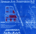 | Details | Lake Shore Realty Co. | 1925 |
| Cyanotype Sales Map of Howard Avenue Subdivision No. 2 Chicago |
|
Lake Shore Realty Co. |
|
| 1925 |
| LOC:88 |
| $350.00 | Lake-Shore-Realty-Co- | Cyanotype-Sales-Map-of-Howard-Avenue-Subdivision-No--2-Chicago | Authentic cyanotype (blueprint) Chicago-area map from 1925 with interesting illustrations of local transportation including an electrified trolley and coal-fired steam locomotive. A fine, unique early 20th century artifact that should appeal to advertising collectors or others with interests in Evanston or Chicago, Illinois and the expansion into the suburbs. Dated within to 5/28/25. Drawn by J.R.W.A.
<br></br>
Right-hand side of this neat piece shows a large scale map with major streets centered on the Howard Ave Subdivision No 2. Concentric circles drawn at one mile intervals for 3 miles total radius. Left hand large-scale map of the Subdivision with side streets Jonquil Terrace, Lehigh Ave., Dobson Street, and North Meade Ave. Lots already sold are highlighted with dark red pencil.
<br></br>
The new subdivision was located at the intersection of Gross-Point Road and Howard Ave (now Street). Also crossing that intersection is a proposed trolley car line on Howard Ave. and the Chicago, Milwaukee and St. Paul R.R. with a locomotive drawn heading northbound pulling a freight car and four passenger cars.
<br></br>
Text describes restrictions, title guarantor, and contact details for the Lake Shore Realty Co. at Consumer's Building Room 1716. 220 State Street. Phone Wabash9180.
<br></br>
Restrictions were: " Howard Ave is restricted to business buildings of stone or brick construction, two or more stories high. Balance is restricted to residence or apartment buildings of stone or brick construction." Titles guaranteed by Chicago Title & Trust Co.
<br></br>
In the 19th century blueprints (cyanotype prints) were generally scarce as blueprinting had only been invented in the 1870's and by 1899 the process was beginning to become widely adopted as a quick method of reproducing maps, plans, and architectural diagrams. Blueprinting was a well-accepted business tool in 1925 but no other copy of this map is found online. |