| | Thumbnail | | Creator | Date | Title / Author / Date / Location | Price | | | Description |
| 1390 | 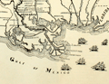 | Details | Lane, Walter A. | 1884 |
| Antique Civil War era map of the Gulf Coast |
|
Lane, Walter A. |
|
| 1884 |
| LOC:0 |
| $0.00 | Lane--Walter-A- | Antique-Civil-War-era-map-of-the-Gulf-Coast | SOLD
<br></br>
Neat decorative original antique map of the southeast Gulf Coast during the U.S. Civil War. Includes locations and features in Texas, Louisiana, Mississippi, Alabama, Florida and the surrounding states. Shows key forts including Fort Pike, Fort Pickens, Fort Jackson, Fort St. Philip and Fort McComb. Includes numerous railroad lines, the key to rapid re-supply. Lane shows and names all the Mississippi River passes (ex. "Pass a Loutre") and fills the empty space in the Gulf of Mexico with depictions of six sailing vessels, some with obvious smoke stacks signifying the use of steam power to assist the sails.
<br></br>
From "The Soldier in Our Civil War" by Frank Leslie. Text and wood-cut images on verso. Dotted line shows the path of Grierson's raid, an attack by 1700 Union cavalry on Baton Rouge, Lousiana in 1863 over routes no Union soldier had traveled prior to the raid. |