| | Thumbnail | | Creator | Date | Title / Author / Date / Location | Price | | | Description |
| 4741 | 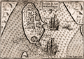 | Details | Langenes, Barent | 1598 |
| Rare antique map of Mozambique Island, Mozambique |
|
Langenes, Barent |
|
| 1598 |
| LOC:77 |
| $150.00 | Langenes--Barent | Rare-antique-map-of-Mozambique-Island--Mozambique | Very fine early miniature map of <b>Mozambique Island</b>, nearby the coast of Mozambique between the Mozambique Channel and Mossuril Bay. Prior to 1898, Mozambique Island was the capital of colonial Portuguese East Africa. There the Portuguese established a port in 1507 and built the Chapel of Nossa Senhora de Baluarte in 1522, now considered the oldest European building in the Southern Hemisphere. North is oriented to the right.
<br></br>
Title cartouche on the upper right side. Two anchored ships and three men fishing with a seine on a small boat are depicted. Latin text on verso. Page 498. |
| 761 |  | Details | Langenes, Barent | 1600 |
| Antique map of the Gulf of Venice and Veneto, Italy |
|
Langenes, Barent |
|
| 1600 |
| LOC:0 |
| $0.00 | Langenes--Barent | Antique-map-of-the-Gulf-of-Venice-and-Veneto--Italy | SOLD
<br></br>
Attractive antique map of a portion of the Veneto region of Italy including most of the Gulf of Venice and Venetian lagoon from south of Chioggia ( Cioza ) extending northward past Venice ( Venetia ). The title of the map 'Patavinum', ca. 1600 reflects the fact that it is more or less centered on Padua, called Patavium by the Romans. Named features include towns and islands of Padua, Murano, Torcello, Porto de Sant Erasmo , Porto de Malamocco, Porto de San Nicolò al Lido, Cavarzere, Piove di Sacco, and Monselice.
<br></br>
Map carries the signature of Dutch engraver and globe maker Peter Kaerius (1571-1646) at lower right corner. French text on verso. Probably from one of three editions of the French version of the 'Thresor de Chartes Contenant les Tableaux de Tous le Pays du Monde' published in the early 17th century (1600, 1602, and 1609)
(Source: http://www.septentrionalium.com/Book2_entry1.pdf). |
| 3646 | 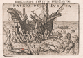 | Details | Langenes, Barent | 1620 |
| Scarce antique print of fantastical lobsters attacking a shipwrecked crew at Ludia |
|
Langenes, Barent |
|
| 1620 |
| LOC:1 |
| $375.00 | Langenes--Barent | Scarce-antique-print-of-fantastical-lobsters-attacking-a-shipwrecked-crew-at-Ludia | Antique copper engraved plate of fantastical crustaceans attacking a shipwrecked crew in the shallows. After van Linschoten's account of the grounding of the ship St. Jacques in 1568 off the island of Ludia near Cabo Corrientes in Mozambique, Africa. The print was first published by Cornelius Claesz and printed by Barent Langenes in 1598. Engraved by Peter van den Keere. Later edition, circa 1620.
<br></br>
Cape Corrientes was regarded by early Portuguese mariners as one of the most terrifying obstacles facing sailing ships in the Indian Ocean. It is named after the exceptionally fast southward current that passes here. It is also a confluence point of winds, with the capacity to produce violent gusts. Guinote estimated that 30% of the ships lost in the yearly Portuguese India Armadas in the 16th and 17th centuries capsized around Cape Corrientes, more than any other location. (Online: https://en.wikipedia.org/wiki/Cape_Correntes) |