| | Thumbnail | | Creator | Date | Title / Author / Date / Location | Price | | | Description |
| 1408 | 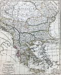 | Details | Lapie, Pierre | 1816 |
| Antique map of Greece and the Balkans |
|
Lapie, Pierre |
|
| 1816 |
| LOC:2 |
| $95.00 | Lapie--Pierre | Antique-map-of-Greece-and-the-Balkans | Antique map of Greece and the Balkans, including the regions of Romania, Bulgaria, Bosnia, Serbia and part of the Black Sea with the western part of Turkey including Constantinople. Much detail about the Greek archipelago. Coverage on this interesting engraved map extends as far south as the island of Crete ("Candie") and encompasses portions of the Ionian Sea, the Mediterranean Sea, the Black Sea, and the Adriatic Sea. Page 27.
<br></br>
Pierre M. Lapie (1779-1850) was a French cartographer and engraver. Lapie, a Colonel in the French army, worked in the corps of topographical engineers. |
| 1409 | 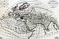 | Details | Lapie, Pierre | 1816 |
| Antique map of Asia |
|
Lapie, Pierre |
|
| 1816 |
| LOC:6 |
| $120.00 | Lapie--Pierre | Antique-map-of-Asia | Very nice antique map of the eastern hemisphere or the entire world as it was known to exist in ancient times. Notations on the map reference Pliny, Ptolemy, Eratosthenes and other very early Greek historians and geographers. Includes north Africa, Mediterranean Sea, India, Europe, Arabia,and western Asia. Upper left corner contains diagram with names of the winds.
<br></br>
Pierre M. Lapie (1779-1850), a Colonel in the French army, was a French cartographer and engraver. Lapie worked in the corps of topographical engineers. Pierre was the father of cartographer Alexandre Emile Lapie. In the first half of the 19th century, the work of the Lapie firm, with its precise engraving and informational density, strongly influenced their German competitors whose maps would eventually dominate the continental European market. |