| | Thumbnail | | Creator | Date | Title / Author / Date / Location | Price | | | Description |
| 3595 | 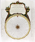 | Details | Laurie and Whittle | 1794 |
| Antique Tide Calculator for the North Sea, Bay of Biscay, and the English Channel |
|
Laurie and Whittle |
|
| 1794 |
| LOC:0 |
| $0.00 | Laurie-and-Whittle | Antique-Tide-Calculator-for-the-North-Sea--Bay-of-Biscay--and-the-English-Channel | SOLD <br></br>
Fine antique <b>volvelle for calculating the time of tides</b> at numerous locations in the UK and on the coast of Europe. A volvelle or wheel chart is a type of calculator constructed from paper. Essentially, a very early and simple analog computer. With a rotating dial for Locations and Minutes. Outside the rotating dial, are fixed a 30 Day Circle and a 12 Hours Circle and Names of Places including Lizard Point, The Coast of Flanders, Tinmouth Bar, Flamborough Head, Calais, the River of Bordeaux, and many more.
<br></br>
On this scarce device the instructions read <div class="indenttextblock">"To make use, you must place the Flower-de-Luce, or Index, to the Day of the Moon's age, on the circle of days and the Arrow, at the end of the line wherein the name is written, will point to the time of the Tides Flowing or Running that day, on the circle of hours."</div>
Published by Laurie & Whittle, 53 Fleet Street. March 12, 1794. |
| 5128 |  | Details | Laurie and Whittle | 1795 |
| Original Rare 18th Century Heraldic Print A Chart of Blazonry |
|
Laurie and Whittle |
|
| 1795 |
| LOC:62 |
| $1,800.00 | Laurie-and-Whittle | Original-Rare-18th-Century-Heraldic-Print-A-Chart-of-Blazonry | A Chart of Blazonry. Engraved pictorial chart, uncolored, of the components of a blazon or heraldic device. The chart is essentially a reference work, a visual dictionary that allows the conversion of textual descriptions of a blazon into its visual image.
<br></br>
Rare. No copies found anywhere online.
<br></br>
Blazonry, a part of heraldry, is the formal description or illustration of coats of arms. Blazonry embodies a grammar and vocabulary which describe the meaning of a blazon. The field of heraldry, of ancient origin, is the system by which coats of arms and other armorial bearings are devised, displayed, described, recorded and granted.
<br></br>
Published on March 30, 1795 by Laurie and Whittle no. 53 Fleet Street, London.
<br></br>
Engraved by Robinson |
| 181 |  | Details | Laurie and Whittle | 1798 |
| Plymouth Sound---- SOLD |
|
Laurie and Whittle |
|
| 1798 |
| LOC:0 |
| $0.00 | Laurie-and-Whittle | Plymouth-Sound-----SOLD | This item has been sold. <br></br>
Very cool antique nautical chart by Laurie and Whittle from 1798 of the Hamoaze and Catwater rivers, port of Plymouth, England and Plymouth Sound. Plymouth has a long distinguished history as a maritime port. This old sea chart of Plymouth Sound shows the location of many historic locations including a hill known as the Hoe, where legend says Francis Drake was to have insisted on completed a game of bowls before setting out to meet the invading Spanish Armada of 1588 led by the Duke of Medina Sidonia (Drake knew the tide was not in his favor at the time he was notified of the approaching Spanish fleet).<br></br>
Attractive title cartouche with date. Copious sailing directions, soundings, landmarks (especially churches), and navigational hazards are noted. The chart is an attractive record of the days when the town Plymouth was smaller in size, but no less important to England. |
| 773 | 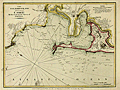 | Details | Laurie and Whittle | 1810 |
| Antique Chart of the Bay, Harbor, and Environs of Cadiz, Spain |
|
Laurie and Whittle |
|
| 1810 |
| LOC:4 |
| $275.00 | Laurie-and-Whittle | Antique-Chart-of-the-Bay--Harbor--and-Environs-of-Cadiz--Spain | Attractive nautical antique chart of the Bay of Cadiz, Spain published by British entrepreneurs Laurie and Whittle in 1810. Some of the key features noted in English include the settlements of Rota, Port Santa Maria, Port Royal ( Puerto Real ), Trocadero, St. Carlos Town and Cadiz, Spain. Other features include the Battery of la Gallina, Rio Salado, Castle of Santa Cataline, Convent of la Victoria, Bridge of Boats, Channel of Trocadero, and the Arsenal of the Carracas. On the Isle of Leon are located Torre Gorda or Hercules' Tower, Saint Carlos Town, Martyr's Hill, Castle of Puntales, Fort San Fernando, and the walled town of Cadiz itself with the Castle and Lighthouse of Saint Sebastian jutting westward into the Atlantic Ocean.
<br></br>
Notations of soundings, bottom composition, shoals and other navigational hazards would have made this chart useful to early 19th century sailors.
<br></br>
Publishers attribution at bottom reads: 'Published by Robert Laurie and James Whittle, Chart sellers to the Admiralty, &c &c. No. 53 Fleet Street, London. May 24, 1810.' This antique harbor plan / chart is an original copperplate engraving with later hand coloring based on the work of Spanish cartographer Tofino de San Miguel. Watermarked chain laid paper with the watermark date of 1805. |