| | Thumbnail | | Creator | Date | Title / Author / Date / Location | Price | | | Description |
| 4848 | 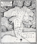 | Details | Laval, Antoine | 1728 |
| Scarce antique chart of Bahia Honda, Cuba |
|
Laval, Antoine |
|
| 1728 |
| LOC:13 |
| $250.00 | Laval--Antoine | Scarce-antique-chart-of-Bahia-Honda--Cuba | Antique copperplate engraved harbor chart shows Bahia Honda, Cuba as it existed in 1720. Bahia Honda, is located about 50 miles west of Havana in Artemisa province on the north-western coast of Cuba. Laval's chart predates Thomas Jeffery's "Plan of Bahia Honda" by more than 35 years and is the earliest known detailed harbor chart of Bahia Honda. It does not appear, however that Laval's map is based on any observations made by him as the ship he was on seems to have bypassed the Bay entirely on its way to Havana.
<br></br>
From the report of French astronomer and Jesuit Priest, Antoine Laval (1664-1728): "Voyage de la Louisiane", an account of the 1720 expedition to the Florida and Louisiana coasts led by French officer Valette de Laudun. Laval is recorded as mathematician or astronomer on that voyage. Laval was a professor of hydrography and mathematics based in the city of Toulon, France. Page 137.
<br></br>
Vallette de Laudun led the French expedition to Dauphin Island in the Gulf of Mexico between March and November, 1720. The 262-member crew embarked from Toulon, France, on the ship Toulouse , encountering Madeira, Martinique, Saint-Domingue, and Cuba before entering the Gulf of Mexico. Following a month at Dauphin Island, the expedition returned to France. |
| 4827 | 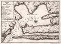 | Details | Laval, Antoine | 1728 |
| Rare early map of Pensacola for collectors |
|
Laval, Antoine |
|
| 1728 |
| LOC:0 |
| $0.00 | Laval--Antoine | Rare-early-map-of-Pensacola-for-collectors | SOLD
<br></br>
Similar to, but substantially different from Bellin's later chart of Pensacola, Florida. A rare, early (1728) chart of Pensacola Bay and Escambia Bay by Father Antoine Laval. Laval's chart could be considered a foundational map for collectors as it is the first detailed printed chart of the area. The three attributes of the map that differ most between Laval's map of 1728 and Bellin's later 1744 map are:
<div class="indenttextblocksingle">
<ul>
<li>Number of depth soundings. (Laval has many more soundings.)</li>
<li>Number of places named. (Bellin has more names.)</li>
<li>Alignment of Santa Rosa Island. (Laval's chart does not show the curvature that Bellin's later chart proposes.)</li>
</ul>
</div>
This map was included in the report of French astronomer Father Antoine Laval: "Journal d'un voyage de la Louisiane", an account of the 1720 expedition to the Florida and Louisiana coasts led by Valette Laudun. Laval is recorded as mathematician or astronomer on that voyage. The account included astronomical observations taken by Laval from a point on nearby Dauphin Island. (Source: oldmaps.com) From 1718 Laval was a Royal Professor of Hydrography based in the city of Toulon, France.
<br></br>
Boran explains the historical context for viewing Laval’s decision to provide his readers with a map of Pensacola:
<div class="indenttextblocksingle">
"… should be viewed in the light of military and political developments in France during the period 1718-1720. The War of the Quadruple Alliance had broken out in 1718 and Pensacola, was now deemed a strategic target (presumably because of its proximity to their base at Dauphin Island). In May 1719 the Lemoyne brothers ... took the port for the French. The Company of the West … decided to move their headquarters to Pensacola, given its potential as a port." (Boran, Elizabethanne. Travelling to Louisiana in 1720. Online: edwardworthlibrary.ie).</div> |
| 4829 | 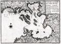 | Details | Laval, Antoine | 1728 |
| Rare early map of Fort Royal Bay, Martinique |
|
Laval, Antoine |
|
| 1728 |
| LOC:13 |
| $500.00 | Laval--Antoine | Rare-early-map-of-Fort-Royal-Bay--Martinique | Rare, earliest (1728) chart of the entirety of Fort de France Bay. By Father Antoine Laval. Laval's antique chart of Fort Royal, based on surveys of 1720, should be considered a foundational artifact for collectors of Caribbean Island cartography as it is the first detailed printed chart to cover the entire Baie de Fort de France on the island of Martinique. It was almost 35 years later when the next accurate harbors plans of the "Cul de Sac Royal" were printed by Bellin (1764) and by Caylus (1760).
<br></br>
This map was included in the report of French astronomer Father Antoine Laval: "Voyage de la Louisiane", an account of the 1720 expedition to the Florida and Louisiana coasts led by French officer Valette de Laudun. Laval is recorded as mathematician or astronomer on that voyage. Laval was a professor of hydrography and mathematics based in the city of Toulon, France. Page 48.
<br></br>
Vallette de Laudun led the French expedition to Dauphin Island in the Gulf of Mexico between March and November, 1720. The 262-member crew embarked from Toulon, France, on the ship Toulouse , encountering Madeira, Martinique, Saint-Domingue, and Cuba before entering the Gulf of Mexico. Following a month at Dauphin Island, the expedition returned to France. |