| | Thumbnail | | Creator | Date | Title / Author / Date / Location | Price | | | Description |
| 1175 | 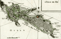 | Details | Le Rouge, George | 1756 |
| Antique map of Isle de Re, France |
|
Le Rouge, George |
|
| 1756 |
| LOC:0 |
| $0.00 | Le-Rouge--George | Antique-map-of-Isle-de-Re--France | SOLD
<br></br>
Fine antique map of the Île de Re in the Charente-Maritime department of western France. Much emphasis on the numerous rocky outcrops, and points that endangered shipping. Contains detailed depictions of the redoubts and forts protecting the island's beaches. Features include Redoutte de Sablanceau, Fort de la Pree, la Flotte, and the walled village of Saint-Martin. The island's south coast is ominously labeled "Cote de la Mer Sauvage". From George le Rouge's "Atlas Nouveau Portatif à l'usage des militaires et du voyages."
<br></br>
The main port of the Île de Ré, Saint-Martin, was fortified by Vauban in 1681 as a one of many forts and citadels built to protect the military harbour of Rochefort. The island was later used as a depot for convicts on their way to the penal settlements of New Caledonia and French Guiana. The old city of Saint-Martin, within the walls of the citadel, was added in 2008 to the World Heritage Site list, along with 11 other fortifications of Vauban across France.
<br></br>
George Le Rouge was a Paris-based engineer and surveyor who had a shop on the Rue Des Grands Augustins, Paris. Le Rouge's tireless work earned him the title "Geographe du Roi". Number 48. |
| 423 | 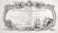 | Details | Le Rouge, George | 1757 |
| Title Page from Recueil des Cotes Maritimes de France |
|
Le Rouge, George |
|
| 1757 |
| LOC:0 |
| $150.00 | Le-Rouge--George | Title-Page-from-Recueil-des-Cotes-Maritimes-de-France | Title page from an atlas of the coasts of France, "Recueil des Cotes Maritimes de France", printed in 1757. The copperplate engraving shows a scene of ships navigating near a rocky coast inset into a decorative scroll-work cartouche decorated with implements of war. Dedicated to the Comte de Clermont.<BR> </BR>
<b>George Le Rouge<b> (1712-1790)was a German-born Paris-based engineer and surveyor who had a shop on the Rue des Grands Augustins. Le Rouge's tireless work for the King earned him the title <b>"Geographe du Roi". </b>
<BR> </BR>
Le Rouge's important works include his edition of the Franklin/ Timothy Folger chart of the Gulf Stream (after Franklin [1]) " and the Pilote américain septentrional (1778) which published Plan de Boston avec les Sondes et les Directions pour la Navigation : traduit de l'Anglais" and "Ocean Atlantique et Mers Adjacentes en quatre feuilles…"
[1] Mount and Page. London. 1768. |
| 1126 | 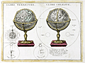 | Details | Le Rouge, George | 1760 |
| Terrestrial and celestial globes |
|
Le Rouge, George |
|
| 1760 |
| LOC:0 |
| $180.00 | Le-Rouge--George | Terrestrial-and-celestial-globes | Antique old French copper-plate engraving ca. 1748 of two globes: a terrestrial globe and a celestial globe. A celestial globe is a spherical representation of the celestial sphere, showing the apparent positions of the stars and constellations in the sky. The engraving includes additional representations: of the points of the compass, a solar eclipse, lunar eclipse, and the relative sizes of the astronomical bodies.
<br></br>
From le Rouge's "Atlas Nouveau Portatif à l'usage des militaires et du voyageur" published from Paris. George Le Rouge was a Paris-based engineer and surveyor originally from Germany who had a shop on the Rue Des Grands Augustins. Le Rouge's tireless work earned him the title "Geographe du Roi". |
| 506 | 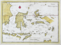 | Details | Le Rouge, George | 1767 |
| Isles Moluques |
|
Le Rouge, George |
|
| 1767 |
| LOC:6 |
| $185.00 | Le-Rouge--George | Isles-Moluques | Antique map of the Moluccas (Malaku Islands) in Asia, an archipelago within Indonesia. These islands were once referred to as the "Spice Islands". Plate 82. Coverage includes Bali, Borneo, Sulawesi (Celebes Isle) , East Java, Timor, Ambon, Ceram, and Western New Guinea. |
| 734 | 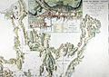 | Details | Le Rouge, George | 1778 |
| Antique Chart of Narragansett Bay with Newport Rhode Island |
|
Le Rouge, George |
|
| 1778 |
| LOC:0 |
| $0.00 | Le-Rouge--George | Antique-Chart-of-Narragansett-Bay-with-Newport-Rhode-Island | SOLD
<br></br>
Scarce original antique sea chart of Narragansett ( Narraganset ) Bay, parts of Rhode Island and Massachusetts. Geographic features include Mount Hope Bay, Bristol Bay, Providence River, and Taunton River. Named towns include Swansea and Dighton, Massachusetts; Bristol, Providence, Warren, Barrington, and East Greenwich, Rhode Island. Fall River, Mass. is not named, but in its place are shown two dwellings atop a hill by the side of the "Fals River ou Riviere des Sauts".
<br></br>
Published by George Le Rouge in Volume 1 of his rare sea-atlas "Pilote Américain Septentrional " (below) from Paris, France in 1778. Large inset plan of Newport, Rhode Island at top center with street and structures shown in great detail and with many key landmarks about Newport described by a legend.
<br></br>
This scarce chart is derived from J.F.W. des Barres’ 1776 chart which was based on surveys made by Charles Blaskowitz on behalf of the British Board of Trade in the early 1770s. Le Rouge's sea-atlas was intended for use by British Navy navigators at sea and few copies have survived that harsh environment.
<img src="/ZoomifyImages/SC_734/PiloteAmericain_400x300.jpg" align="left" style="PADDING-RIGHT: 8px; PADDING-Top: 15px" alt="Title page: Pilote Américain Septentrional." title="Title page for le Rouge's atlas: Pilote Américain Septentrional. Source: www.europeana.eu" width="160"> |
| 1167 | 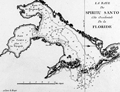 | Details | Le Rouge, George | 1778 |
| Scarce early nautical chart of Tampa Bay, Florida |
|
Le Rouge, George |
|
| 1778 |
| LOC:200 |
| $1,500.00 | Le-Rouge--George | Scarce-early-nautical-chart-of-Tampa-Bay--Florida | Fine and very scarce copper-plate engraved harbor chart of the "Baye du Spiritu Santo" comprised of "Bay de Tampa" and the "Baye de Hillsborough", by George le Rouge, from Paris. Coverage on this fine historic French nautical artifact covers areas in Florida that are today's <b>St. Petersburg, Tampa, Brandon, Bradenton and Sarasota</b>. Only one sale recorded in AMPR, 28 years ago.
<br></br>
Le Rouge noted only a few key features including: two references to "Eau douce" (Trans. 'sweet water'); a location noted as "Black Rocks"; "Egmont Island"; and "Long Island" (today's Longboat Key).
<br></br>
From Pilote américain septentrional by <b>George le Rouge</b>, this is one of the <b>earliest available large-scale nautical charts of Tampa Bay</b> with the entrance to the Gulf of Mexico. Rouge's Pilote américain septentrional drew heavily upon the work of William Faden and Thomas Jefferys. The maps were modified with French nomenclature but their British origin explains why some place names are in English. Latitude is noted but no metrics exist for longitude. Distance scale is in English miles. Manuscript number "27" in upper right. |