| | Thumbnail | | Creator | Date | Title / Author / Date / Location | Price | | | Description |
| 1034 | 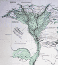 | Details | Leake, William Martin | 1818 |
| Map of Egypt, Nile River |
|
Leake, William Martin |
|
| 1818 |
| LOC:1403 |
| $1,295.00 | Leake--William-Martin | Map-of-Egypt--Nile-River | Very large and impressive <b>full-width example</b> of Leake's map of the Nile river from 1818 (29" x 50" at neatline). Rolled, and <b>NOT dissected.</b> Clean, bright, and strong. Scarce, as the map is not dissected and is in fine condition. Guaranteed original copper-plate engraved map by Sidney Hall for Aaron Arrowsmith. Dated at bottom to 1818. Two sheets well joined.
<br></br>
Published by Aaron Arrowsmith who in his early twenties worked for John Cary, the engraver and William Faden. Aaron Arrowsmith (1750-1823) founded a cartographic dynasty and was a close contemporary of Alexander Dalrymple (Hydrographic Office), Joseph Banks (Naturalist), Flinders and others of the period. Arrowsmith became Geographer to the Prince of Wales in 1810 and ultimately <b>Hydrographer to the King</b> in 1820.
<br></br>
This hand-colored, original map "Course of the Nile" was produced by Lieutenant Colonel W.M. Leake. William Martin Leake, a leading British authority on the region. In 1802, Leake and others were employed to make a general survey of Egypt. Leake's chart was published in 1818 after his retirement, incorporating additional material from Bryce and others. The map provides extensive information on the Nile, archaeological sites, the Sea of Suez, roads and railways. Numerous annotations are included about the areas extensive history and its inhabitants. Note: The Suez Canal is not included in this chart because that waterway was not completed until 1869, more than 50 years after this map was published. |