| | Thumbnail | | Creator | Date | Title / Author / Date / Location | Price | | | Description |
| 1449 | 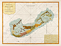 | Details | Lempriere, Clement | 1775 |
| Bermuda or Summer's Island West-India Atlas Lempriere Jefferys Sayer |
|
Lempriere, Clement |
|
| 1775 |
| LOC:51 |
| $4,500.00 | Lempriere--Clement | -Bermuda-or-Summer-s-Island-West-India-Atlas-Lempriere-Jefferys-Sayer | <div class="indenttextblock">
"This coast is the boldest in Bermuda and in some places the Largest Ships may with safety come within half gun shot of shore."
</BR></BR>
"Here in the months of March, April, and May they Fish for Whales."
</div>
</BR>
Above are a few of the notes from this fine antique chart of Bermuda. An extremely desirable British chart titled: "The Bermuda's or Summer's Islands." After a survey by Clement Lempriere. This is from the scarce <b>first issue of The West-India Atlas, 1775 by Sayer</b>, the other issues being 1781, 1787, 1794, 1796, 1807, and 1818 published by Sayer and later Laurie and Whittle.<a href="https://www.davidrumsey.com/home" target="_blank">(Online).</a>
<br></br>
On age-appropriate laid watermarked paper with a fleur-de-lis surmounted by a crown
<br></br>
During Bermuda's colonial period ca. 1615 the island was divided into eight equally-sized administrative areas west of St. George's called <b>"tribes" (parishes)</b>. These "tribes" were areas of land partitioned off to the principal investors of the Somers Isles Company.
<br></br>
From: "The West-India Atlas: or, A Compendious Description of the West-Indies: illustrated with Forty Correct Charts and Maps, taken from Actual Surveys. …"
Authors: Clement Lempriere (original survey), Thomas Jefferys.
Publishers: Robert Sayer.
Jefferys died in 1771; Sayer acquired Jefferys' materials in preparation for this atlas, and published the atlas posthumously under his name. |