| | Thumbnail | | Creator | Date | Title / Author / Date / Location | Price | | | Description |
| 1265 | 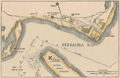 | Details | Leslie, Frank | 1884 |
| Antique map of south Pensacola, Florida and Navy Yard |
|
Leslie, Frank |
|
| 1884 |
| LOC:0 |
| $0.00 | Leslie--Frank | Antique-map-of-south-Pensacola--Florida-and-Navy-Yard | SOLD
<br></br>
Antique map ''The United States Navy Yard. Pensacola Bay, Fla. Santa Rosa Island, and the Gulf of Mexico and Bay Forts''. This very attractive old map features the south <b>Pensacola</b> area during the Civil War, showing Fort McRae, Fort St. Carlos de Barrancas ( Barancas ), and <b>Fort Pickens</b>, barracks, marine hospital, cemetery, and U.S.Navy Yard. Shows the nearby communities of Warrington and Woolsey and a single road following the coastline to Pensacola.
<br></br>
Cartography after an earlier 1861 map published in Harper's Weekly. This later, updated map shows the Marine Hospital built in 1870. Source is Frank Leslie's <b>The Soldier in our Civil War</b>, one of the most lavish pictorial histories of the Civil War ever published.
<br></br>
The Pensacola Navy Yard was a shipyard at the site of present-day Naval Air Station (NAS) Pensacola. Originally constructed in 1826, it was decommissioned in 1911. The site was reopened three years later as Naval Air Station Pensacola.
<br></br> |