| | Thumbnail | | Creator | Date | Title / Author / Date / Location | Price | | | Description |
| 21 |  | Details | Levanto, Francesco M. | 1664 |
| La Costa di SPAGNA |
|
Levanto, Francesco M. |
|
| 1664 |
| LOC:8 |
| $900.00 | Levanto--Francesco-M- | La-Costa-di-SPAGNA | Rare nautical chart of the Mediterranean coast of southern Spain including Alicante and Cartagena Spain and of the North African coastline including Oran and Cape Ferrat. Portolan-style central compass rose surrounded by a concentric grouping of rhumb lines. <BR> </BR>
Produced by the Genoan cartographer Francesco Maria Levanto in 1664 in "La Prima Parte dello Specchio del Mare…" (Sea Mirror) probably from earlier Dutch charts, possibly by Jacobsz. This antique sea chart was reissued later by Coronelli in 1697. Charts from Levanto's Specchio del Mare are quite scarce. Plate 5. Chain laid paper. |
| 18 | 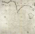 | Details | Levanto, Francesco M. | 1664 |
| Carta Maritima della Meridionale Costa di MOREA |
|
Levanto, Francesco M. |
|
| 1664 |
| LOC:8 |
| $900.00 | Levanto--Francesco-M- | Carta-Maritima-della-Meridionale-Costa--di-MOREA | Rare Genoan antique nautical chart of the Greek coast including the named islands of Sapienza, Schiza, I. Cervij ( Elafonisos ), Serigo (Kythera), and Serigotto (Antikythera), Greece. Antikythera is best known for being near the site at which the so-called <b>Antikythera mechanism</b> was recovered by sponge divers in 1900. That mechanism is an early clockwork device with meshed bronze gears that allowed the user to calculate the position of astronomical objects, eclipses, and lunar phase by rotating a hand crank. The significance of the device is that it is believed to date from antiquity- 67 BC and is by far the oldest analog computer ever discovered.
<BR> </BR>
Coverage includes a long stretch of the southern coast of the <b>Peloponnese peninsula</b>, known in earlier times as the Morea. Primary geographic features include Cape Matapan and Cape Maleo ( Cap San Angelo) with the following settlements identified by name: Modon ( Methoni ), Coron ( Koroni ), Vitulo ( Porto Vitilo ). Porto Rapini is a bit more difficult to identify but based on 19th century works only present-day Marathias fits the location. Almost 2 centuries after this chart was published, Norie described Porto Rapina: <div class="indenttextblock"> "you will see a long even point of land and behind it two round hills" . . . "there are two small islands before the northern entrance to the port" and noted that the Island of Cervi was "7 miles southward". </div> That description fits only Marathias. (Norie, John William. New Mediterranean Pilot. 1817, p 140.)
<BR> </BR>
This old sea chart was produced by Genoan cartographer <b>Francesco Maria Levanto</b> in 1664. Levanto's "La Prima Parte dello Specchio del Mare" (Sea Mirror) was probably based on earlier Dutch charts, possibly by Jacobsz.
<BR> </BR>
This chart was reissued about 40 year later by Coronelli. Charts from the Specchio del Mare are quite scarce. Plate 17. Oriented North at top. Chain laid paper. |
| 358 | 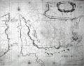 | Details | Levanto, Francesco M. | 1664 |
| Carta Maritima del Golfo di Smirne |
|
Levanto, Francesco M. |
|
| 1664 |
| LOC:8 |
| $1,225.00 | Levanto--Francesco-M- | Carta-Maritima-del-Golfo-di-Smirne | Rare, original antique portolan-style sea chart of east coast of Chios, Greece and the coast of Turkey around Izmir by Genoan cartographer Francesco Maria Levanto. Charming oblique profile depictions of Smirne (Izmir) and Soi (Chios, Greece). Charts of Turkey from the mid 17th century are quite scarce.<BR> </BR>
From Levanto's "La Prima Parte dello Specchio del Mare" (Sea Mirror). Probably based on earlier Dutch charts, possibly influenced by Jacobsz. Place names and notes in Dutch and Italian. With an inset coastal profile and an elaborate decorative cartouche.<BR> </BR>
This chart was reissued about 40 year later by Coronelli. Charts from the Specchio del Mare are quite scarce. |