| | Thumbnail | | Creator | Date | Title / Author / Date / Location | Price | | | Description |
| 5375 | 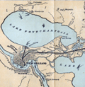 | Details | Louisville and Nashville Railroad | 1886 |
| Birds Eye View of Gulf Coast Louisville and Nashville Railroad |
|
Louisville and Nashville Railroad |
|
| 1886 |
| LOC: |
| $725.00 | Louisville-and-Nashville-Railroad | Birds-Eye-View-of-Gulf-Coast-Louisville-and-Nashville-Railroad | </br>"The Great Through Car Line Between the North and South."</br>
"Unrivaled in Speed, Construction and Equipment."
<br></br>
Fine bird's eye view of the central Gulf Coast highlighting the route of the Louisville and Nashville Railroad from Mobile, Alabama, through Mississippi, to New Orleans, Louisiana. The route includes Bay St. Louis, Ocean Springs, Pass Christian, Mississippi City, Biloxi, Pascagoula. Numerous steam-powered and wind-powered vessels are shown plying the waters of the Gulf of Mexico, Lake Ponchartrain and the Mississippi River.
<br></br>
Six-panel folding map, neatly folded inside a 64-page pamphlet (4.5 " x 7.25") titled "The Gulf Coast". With the ink stamp of Sam. B. Jones, General Agent, New York. Published by the passenger department of the Louisville and Nashville R.R.
<br></br>
Printed in Louisville, KY by the Press of the Courier-Journal Job Printing Company. |
| 5096 | 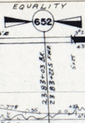 | Details | Louisville and Nashville Railroad | 1971 |
| Lot of 2 scarce Louisville and Nashville Railroad Florida Track Profile Charts |
|
Louisville and Nashville Railroad |
|
| 1971 |
| LOC:0 |
| $600.00 | Louisville-and-Nashville-Railroad | Lot-of-2-scarce-Louisville-and-Nashville-Railroad-Florida-Track-Profile-Charts | Lot of 2 scarce original Louisville and Nashville Railroad Florida track profile charts for their Pensacola & Atlantic Sub-division and Yellow River Branch lines. First printed in 1930 and revised and redrawn in Mobile, Alabama by R.W.P. in October 1971.
<br></br>
Condensed track profile charts are engineering documents giving mile-by-mile documentation of every aspect of a railroad’s right-of-way and trackwork: track layout, grades, curvature, bridgework, etc. Track profile charts may contain:
<div class="indenttextblocksingle">
<ul style="list-style-type: circle;">
<li>Milepost numbers</li>
<li>Direction of the line via compass heading for sub-segments of the line</li>
<li>Slope of the grade for each sub-segment</li>
<li>Details about culverts, bridges, arches, and boxes</li>
<li>Town names</li>
<li>Locations of railway infrastructure (freight depots, passenger stations, and signals) </li>
</ul>
</div>
First printed in 1930, these two volumes were updated in 1971 by "R.W.P."
<div class="indenttextblocksingle">
<ul style="list-style-type: circle;">
<li>The smaller of the two books (Vol. 1) contains track map profiles for 43 miles of track of the Pensacola Division of the L & N R.R. extending south from Flomaton, Alabama to Pensacola, Florida. Includes two pages of railway symbol conventions and common abbreviations; a list of stations on the route; and layouts for the Pensacola, Goulding, and Flomaton rail yards.</li>
<li>The larger volume (Vol. 2) includes track profiles for the Yellow River Branch of the L & N R.R. from Florala to Crestview, Florida and for the Pensacola and Atlantic Branch of the L & N R.R. extending from Pensacola (Red Bluff), Florida eastward to River Junction, Florida. Includes two pages of railway symbol conventions and common abbreviations; a list of stations on the route; and layouts for the Muskogee Wharf, Pensacola, Pace, and River Junction rail yards and facilities.</li>
</ul>
</div> |