| | Thumbnail | | Creator | Date | Title / Author / Date / Location | Price | | | Description |
| 262 | 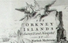 | Details | Mackenzie, Murdoch (Senior) | 1750 |
| Survey of the Orkney and Lewis Islands. (Atlas of 8 folio plates) |
|
Mackenzie, Murdoch (Senior) |
|
| 1750 |
| LOC:0 |
| $5,655.00 | Mackenzie--Murdoch-(Senior) | Survey-of-the-Orkney-and-Lewis-Islands--(Atlas-of-8-folio-plates) | This important, intact, and scarce folio-sized antique atlas of 8 plates is a landmark in cartography by Orkney native Murdoch Mackenzie Senior (1712 - 1797). This antique nautical atlas of the Orkney Islands, published in 1750 is Mackenzie's first published work and is considered to be the most accurate survey in Britain up to the mid 18th century. </br> </br>
<strong><a style="color:#9BAFCB" href= "/MackenzieAtlasViewer.aspx">[ Browse the entire atlas ]</a></strong> </br> </br>
In 1962 A.G.W. Robinson wrote about the unique characteristics of Mackenzie's first charts: "Some of the conventions he adopted, for example showing bottom deposits by a letter under the relevant sounding, are still in use on present day charts."
<br></br>
Contents include Title Page, Subscriber list, A 14 page History of the Orkneys, 8 charts of the Orkneys, Pomona, and the Lewis.
<br></br>
Reference: Robinson, A.H.W. 'Marine Cartography in Britain'. Leicester University Press. 1962. pp. 60-70. |