| | Thumbnail | | Creator | Date | Title / Author / Date / Location | Price | | | Description |
| 688 | 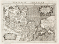 | Details | Magini, Giovanni Antonio | 1598 |
| Asia and U.S. West Coast- Tartariae Imperium |
|
Magini, Giovanni Antonio |
|
| 1598 |
| LOC:6 |
| $450.00 | Magini--Giovanni-Antonio | Asia-and-U-S--West-Coast--Tartariae-Imperium | Very old antique map of China, Japan, Russia, and the West Coast of the United States : "Americae vel Novi Orbis Pars" by G.A. Magini ca. 1598. California is identified by name and is shown attached to the continent. Alaska and Canada are truncated with the coast of North America shown trending to the North rather than to the West. Above North America the Scythian Ocean "Oceanus Scythicus" extends to the Arctic Circle. There is a hint of the Mississippi River drainage but it is greatly misplaced to the West and empties into the "Mar Vermeio" or Vermillion Sea. Also mis-identified is the "Stretto di Anian", part of the much sought after but elusive Northwest Passage. North of Japan, in the vicinity of the Bering Sea, not discovered at that time, the author identifies "Mare Cin".
<br></br>
This old map of Asia is characterized by careful, neat engraving and lettering with the continents set apart from the sea by a finely stippled background.
<br></br>
Coverage includes Cazones, Y. de Cedri (Cedros Island) off the coast of Baja California, "Y delle Perle" or Pearl Islands off the coast of Panama. Cartouches contain Latin inscriptions while the surrounding text is in Italian. After an earlier map by Abraham Ortelius ca. 1570. Page 167. Plate XXVIII (28). |
| 284 |  | Details | Magini, Giovanni Antonio | 1598 |
| Descrittione di Tutto'l Mondo, Secondo la prattica de' Marinari |
|
Magini, Giovanni Antonio |
|
| 1598 |
| LOC:6 |
| $850.00 | Magini--Giovanni-Antonio | Descrittione-di-Tutto-l-Mondo--Secondo-la-prattica-de--Marinari | Exquisitely-engraved small antique chart of the entire world by Tolomeo Magini executed in the style one would find in larger sea charts of the late 16th century, with rhumb lines. At the time the copperplate engraving was made the outlines of the continents were becoming more accurate. This chart reflects those cartographic achievements with the glaring exception of a large southern landmass "Terra Australis Nondum Cognita", which stretches from West to East at the chart bottom. Much finely engraved detail and calligraphy by Porro with stippling throughout all the world's oceans and seas.<BR> </BR>
5" x 7" engraving set in a larger sheet of Italian text measuring 8" x 12". <BR> </BR>
Verso contains text descriptions of Caribbean islands with large woodcut capitals. These descriptions include the islands of Jamaica (L' Isola Iamaica, o di S. Iacomo), Cuba (L' Isole Cuba, o Fernandina) and Canibalori (L'Isole de Canibalori, o de Caribi). Overall a very interesting piece. Chapter 35. |