| | Thumbnail | | Creator | Date | Title / Author / Date / Location | Price | | | Description |
| 815 | 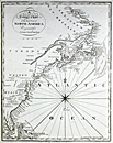 | Details | Malham, John | 1796 |
| A Correct Chart of the East Coast of North America |
|
Malham, John |
|
| 1796 |
| LOC:0 |
| $0.00 | Malham--John | A-Correct-Chart-of-the-East-Coast-of-North-America | SOLD
<br></br>
Antique small-scale copperplate map / chart of the U.S. East Coast published by Spotswood and Nacrede from Boston in September 1796 in Malham's Naval Gazetteer. Indian tribal names are shown, particularly along the St. Lawrence River. These include the Iroquois, Algonkin, and Temiskamings.
<br></br>
Coverage is from the North Coast of Cuba, Florida and Bahamas past the Grand Bank to Labrador. Both latitude and longitude clearly marked as well as numerous rhumb lines. Direction of prevailing current flow for the "Florida Stream" (Gulf Stream) is shown by arrows. Georges Bank is not labeled as such, unlike the later 1801 edition.
<br></br>
This sea chart comes from John Malham's antique nautical gazetteer or geographical dictionary produced first in England and after 1796 in the United States.
<br></br>
Rev. John Malham was a prolific Yorkshire-born author who produced other diverse works that include "Navigation Made Easy and Familiar", "Twenty-Two Sermons on Doctrinal and Practical Subjects" and "The Scarcity of Wheat considered". Malham died near London in 1807. (Gentleman's Magazine, Vol 102, 1807, p. 568). |
| 279 |  | Details | Malham, John | 1797 |
| A Correct Chart of the Southern Coasts of Africa |
|
Malham, John |
|
| 1797 |
| LOC:0 |
| $0.00 | Malham--John | A-Correct-Chart-of-the-Southern-Coasts-of-Africa | <BR> </BR>
SOLD - <BR> </BR>
Small antique nautical chart showing the continent of Africa south of the Equator and the island of Madagascar. From the rare first American edition of Malham's Naval Gazetteer, published by Spotswood and Nancrede in Boston in 1797. Vol 1.<BR> </BR>
This sea chart comes from an early nautical gazetteer or geographical dictionary produced first in England and after 1796 in the United States. Key noted features from this antique copperplate engraving include Madagascar, Cape of Good Hope, Isle France, Isle Bourbon, . Regional African native tribal associations or kingdoms identified include: Bake-bake, Hotentots, Bororos, Zambas, Nimeamai, Bembei, and Biri.<BR> </BR>
Rev. John Malham was a prolific Yorkshire-born author who produced other diverse works that include "Navigation Made Easy and Familiar", "Twenty-Two Sermons on Doctrinal and Practical Subjects" and "The Scarcity of Wheat considered". Malham died near London in 1807. (Gentleman's Magazine, Vol 102, 1807, p. 568).<BR> </BR>
Colophon at end of Volume 1 states that the work is "From the prefs of Samuel Etheridge, No. 9 Newbury Street, Boston, 1797"). |
| 961 | 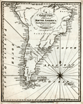 | Details | Malham, John | 1797 |
| A Correct Chart of the Coasts of South America |
|
Malham, John |
|
| 1797 |
| LOC:5 |
| $195.00 | Malham--John | A-Correct-Chart-of-the-Coasts-of-South-America | Antique engraved nautical chart of South America below the Equator from the rare first American edition of <b>Malham's Naval Gazetteer</b>, published by Spotswood and Nancrede in Boston in 1797. Early U.S. colonial nautical chart engravings are scarce. This small chart incorrectly shows Tierra del Fuego as a solid land mass rather than as an archipelago. The area we today know as Argentina is labeled '<b>Patagonia</b>', and the size of the Plate River "Rio de la Plata" is vastly overestimated with its westward extent shown reaching across half the width of the continent. Key cites noted include: Quito, Lima, Buenos Aires, and Sao Paulo.
<BR> </BR>
At extreme upper left of chart the Galapagos Islands are shown, where the largest of the archipelago, Isabella, is designated as 'Albemarle Island' as it was known to the British of that period.
<BR> </BR>
This chart comes from an early nautical gazetteer or geographical dictionary produced first in England and after 1796 in the United States by John Malham. Rev. John Malham was a prolific Yorkshire-born author who produced other diverse works that include "Navigation Made Easy and Familiar", "Twenty-Two Sermons on Doctrinal and Practical Subjects" and "The Scarcity of Wheat considered". Malham died near London in 1807. (Gentleman's Magazine, Vol 102, 1807, p. 568).
<BR> </BR>
Colophon at end of Volume 1 states that the work is "From the prefs of Samuel Etheridge, No. 9 Newbury Street, Boston, 1797"). |
| 962 | 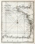 | Details | Malham, John | 1797 |
| A Correct Chart of the Coasts of the Bay of Biscay |
|
Malham, John |
|
| 1797 |
| LOC:0 |
| $0.00 | Malham--John | A-Correct-Chart-of-the-Coasts-of-the-Bay-of-Biscay | SOLD
<BR> </BR>
Antique engraved nautical chart of the Bay of Biscay, probably the earliest small-scale map of Biscay Bay to be printed in the United States (1797). Coverage extends from the coasts of Normandy and Brittany
past Bordeaux and Gascony and terminates in Galicia near Cape Ferrol. Key features include Ushant, Brest, la Rochelle, Rochefort, Bayonne; and the mouths of the Vilaine, Loire, and Gironde Rivers.
<BR> </BR>
Though small in size, the chart contains numerous soundings and descriptions of the composition of the sea-floor (e.g. "Broken Shells", "Grey Sand" or "Whitish Mixt Sand") .
<BR> </BR>
This chart comes from an early nautical gazetteer or geographical dictionary produced first in England and after 1796 in the United States by John Malham. Rev. John Malham was a prolific Yorkshire-born author who produced other diverse works that include "Navigation Made Easy and Familiar", "Twenty-Two Sermons on Doctrinal and Practical Subjects" and "The Scarcity of Wheat considered". Malham died near London in 1807. (Gentleman's Magazine, Vol 102, 1807, p. 568).
<BR> </BR>
Colophon at end of Volume 1 states that the work is "From the prefs of Samuel Etheridge, No. 9 Newbury Street, Boston, 1797"). |
| 278 |  | Details | Malham, John | 1797 |
| A Correct Chart of the West Coast of Africa |
|
Malham, John |
|
| 1797 |
| LOC:6 |
| $0.00 | Malham--John | A-Correct-Chart-of-the-West-Coast-of-Africa | SOLD<br></br>
Small antique nautical chart dated October 1796 showing the Straits of Gibraltar and the west coast of Africa from the Mediterranean Sea to the Gulf of Guinea. From the rare first American edition of Malham's Naval Gazetteer, published by Spotswood and Nancrede in Boston in 1797. Vol 1.<BR> </BR>
This sea chart comes from an antique nautical gazetteer or geographical dictionary produced first in England and after 1796 in the United States. Key noted features include Majorca, Minorca, Corsica, Sardinia, Barcelona, Spain; Madeira, Canary Islands, Cape Verde Islands, and Cape Bojador . Four broad geographical areas or "coasts" are identified: Grain Coast, Gold Coast, Slave Coast, and the Ivory Coast ("Tooth Coast").<BR> </BR>
Rev. John Malham was a prolific Yorkshire-born author who produced other diverse works that include "Navigation Made Easy and Familiar", "Twenty-Two Sermons on Doctrinal and Practical Subjects" and "The Scarcity of Wheat considered". Malham died near London in 1807. (Gentleman's Magazine, Vol 102, 1807, p. 568).<BR> </BR>
Colophon at end of Volume 1 states that the work is "From the prefs of Samuel Etheridge, No. 9 Newbury Street, Boston, 1797"). |
| 419 | 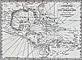 | Details | Malham, John | 1797 |
| A Correct Chart of the West India Islands engraved for Malham's Naval Gazetteer |
|
Malham, John |
|
| 1797 |
| LOC:3 |
| $375.00 | Malham--John | A-Correct-Chart-of-the-West-India-Islands-engraved-for-Malham-s-Naval-Gazetteer | Increasingly scarce on the market. Rev. John Malham's chart of the United States east coast lying south of Charlestown, South Carolina. Covers the Gulf of Mexico, Cuba, Bahamas, Hispaniola, the West Indies, Central America, Columbia, and Venezuela south to the mouth of the Orinoco River. This chart has examples of interesting usage of terms that are today known only from history books: 'Spanish Main' for the southern Caribbean Sea; 'Terra Firma' denotes northern Colombia and Venezuela. Key noted cities include Charleston, Savannah, St. Augustine, New Orleans, Havana, Port Royal, Cartagena, Caracas.
<br></br>
From the rare first American edition of Malham's Naval Gazetteer, published by Spotswood and Nancrede in Boston in 1797. Early U.S. colonial nautical chart engravings are scarce.
<BR> </BR>
This chart comes from an early nautical gazetteer or geographical dictionary produced first in England and after 1796 in the United States by John Malham a prolific Yorkshire-born author who produced other diverse works that include "Navigation Made Easy and Familiar". |
| 420 | 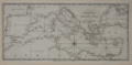 | Details | Malham, John | 1797 |
| A Correct Chart of the Mediterranean Sea engraved for Malham's Naval Gazetteer |
|
Malham, John |
|
| 1797 |
| LOC:0 |
| $0.00 | Malham--John | A-Correct-Chart-of-the-Mediterranean-Sea-engraved-for-Malham-s-Naval-Gazetteer | SOLD<BR> </BR>
Scarce sea chart showing the entire Mediterranean Sea and the Black Sea including the west coast of Spain, Strait of Gibraltar, Majorca, Minorca, Crete, Cyprus, Corsica, Sardinia, Sicily, and Malta . From the rare first American edition of Malham's Naval Gazetteer, published by Spotswood and Nancrede in Boston. Vol 2.<BR> </BR>
This chart comes from an early nautical gazetteer produced first in England and after 1796 in Boston, Massachusetts. Major cities shown include Gibraltar, Cadiz, Seville, Valencia, Barcelona, Florence, Rome, Naples, Venice, Constantinople (Istanbul), Acre, Gaza, and Tunis. With three sets of rhumb lines.
Rev. John Malham was a prolific Yorkshire-born author. Malham died near London in 1807. (Gentleman's Magazine, Vol 102, 1807, p. 568). Archivally matted.<BR> </BR> |
| 421 | 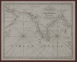 | Details | Malham, John | 1797 |
| A Correct Chart of the Indian Ocean engraved for Malham's Naval Gazetteer |
|
Malham, John |
|
| 1797 |
| LOC:200 |
| $175.00 | Malham--John | A-Correct-Chart-of-the-Indian-Ocean-engraved-for-Malham-s-Naval-Gazetteer | Scarce chart showing the Indian Ocean, Arabian Sea and Bay of Bengal. From the first American edition of Malham's Naval Gazetteer, published by Spotswood and Nancrede in Boston during September 1796. Vol 2.<BR> </BR>
This chart comes from an early nautical gazetteer produced first in England and after 1796 in Boston, Massachusetts. Coverage includes the Persian Gulf, Maldive Islands, Andaman Island, and Nicobar Islands. With three sets of rhumb lines. Rev. John Malham was a prolific Yorkshire-born author. Malham died near London in 1807. Archivally matted.<BR> </BR> |
| 510 |  | Details | Malham, John | 1797 |
| A Correct Chart of the Coast of Portugal engraved for Malham's Naval Gazetteer |
|
Malham, John |
|
| 1797 |
| LOC:7 |
| $185.00 | Malham--John | A-Correct-Chart-of-the-Coast-of-Portugal-engraved-for-Malham-s-Naval-Gazetteer | Early U.S. printed sea chart of Portugal's Atlantic coast from 37 to 42 degrees North Latitude. From the rare first American edition of Malham's Naval Gazetteer, published by Spotswood and Nancrede in Boston. Vol 2.<BR> </BR>
This chart comes from an early nautical gazetteer produced first in England and after 1796 in Boston, Massachusetts. Coverage includes Seville, Cape St. Vincent, Sagres, Setuval, Lisbon, Coimbra, and Oporto. Just below the fleur-de-lis pointing North is a notation: "About this spot is supposed to exist a submarine volcano that occasioned the earthquake Nov 1, 1755." This earthquake, referred to as the "Great Lisbon Earthquake", killed over 10,000 people in Lisbon alone.
Rev. John Malham was a prolific Yorkshire-born author. Malham died near London in 1807. (Gentleman's Magazine, Vol 102, 1807, p. 568).<BR> </BR> |
| 5243 | 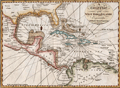 | Details | Malham, John | 1797 |
| A Correct Chart of the West India Islands early Boston published |
|
Malham, John |
|
| 1797 |
| LOC:200 |
| $365.00 | Malham--John | A-Correct-Chart-of-the-West-India-Islands-early-Boston-published | Antique nautical chart showing the east coast of the United States south of Charlestown, South Carolina, the Gulf of Mexico, Cuba, Bahamas, Hispaniola, the West Indies, Central America, Columbia, and Venezuela south to the mouth of the Orinoco River. This chart has examples of interesting usage of terms that are today known only from history books: 'Spanish Main' for the southern Caribbean Sea; 'Terra Firma' denotes northern Colombia and Venezuela. Key noted cities include Charleston, Savannah, St. Augustine, New Orleans, Havana, Port Royal, Cartagena, Caracas.
<br></br>
From the rare first American edition of Malham's Naval Gazetteer, published by Spotswood and Nancrede in Boston in 1797. Early U.S. colonial nautical chart engravings are scarce.
<BR> </BR>
This chart comes from an early nautical gazetteer or geographical dictionary produced first in England and after 1796 in the United States by John Malham. Rev. John Malham was a prolific Yorkshire-born author who produced other diverse works that include "Navigation Made Easy and Familiar", "Twenty-Two Sermons on Doctrinal and Practical Subjects" and "The Scarcity of Wheat considered". Malham died near London in 1807. (Gentleman's Magazine, Vol 102, 1807, p. 568).<BR> </BR> |
| 280 | 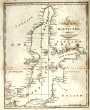 | Details | Malham, John | 1797 |
| A Correct Chart of the Baltic Sea engraved for Malham's Naval Gazetteer |
|
Malham, John |
|
| 1797 |
| LOC:7 |
| $150.00 | Malham--John | A-Correct-Chart-of-the-Baltic-Sea-engraved-for-Malham-s-Naval-Gazetteer | Small antique nautical chart showing the Baltic Sea, Gulf of Finland and surrounding coastal areas including Poland, Estonia, and Sweden (then including Finland). From the rare first American edition of Malham's Naval Gazetteer, published by Spotswood and Nancrede in Boston in 1797. Vol 1.<BR> </BR>
This sea chart comes from an antique nautical gazetteer or geographical dictionary produced first in England and after 1796 in the United States. Key noted cities include Copenhagen, Stockholm, and St. Petersburg. <BR> </BR>
Rev. John Malham was a prolific Yorkshire-born author who produced other diverse works that include "Navigation Made Easy and Familiar", "Twenty-Two Sermons on Doctrinal and Practical Subjects" and "The Scarcity of Wheat considered". Malham died near London in 1807. (Gentleman's Magazine, Vol 102, 1807, p. 568).<BR> </BR>
Colophon at end of Volume 1 states that the work is "From the prefs of Samuel Etheridge, No. 9 Newbury Street, Boston, 1797"). |
| 963 | 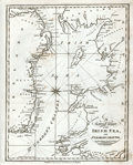 | Details | Malham, John | 1797 |
| A Correct Chart of the Coasts of the Irish Sea and St. Georges Channel |
|
Malham, John |
|
| 1797 |
| LOC:0 |
| $0.00 | Malham--John | A-Correct-Chart-of-the-Coasts-of-the-Irish-Sea-and-St--Georges-Channel | SOLD
<br><br/>
Antique engraved nautical chart of the Irish Sea with the coasts of Scotland, Wales, and Ireland. From the rare first American edition of <b>Malham's Naval Gazetteer</b>, published by Spotswood and Nancrede in Boston in 1797. Probably the earliest small-scale map of the coasts along the Irish Sea to be printed in the United States (1797). Chart coverage extends from Rathlin Island in the North, with the Isle of Man and Angelsey, Solway Firth, Cardigan Bay, and St. Georges Channel terminating past Milford Haven. Key cities include Belfast and Dublin, Ireland; Liverpool, Lancaster; and Carmarthen, Wales.
<BR> </BR>
Adorned with decorative compass rose and three sets of rhumb lines. Unlike several other charts in Malham's volume this example contains no depth soundings or descriptions of the sea-floor composition.
<BR> </BR>
This chart comes from an early nautical gazetteer or geographical dictionary produced first in England and after 1796 in the United States by John Malham. Rev. John Malham was a prolific Yorkshire-born author who produced other diverse works that include "Navigation Made Easy and Familiar", "Twenty-Two Sermons on Doctrinal and Practical Subjects" and "The Scarcity of Wheat considered". Malham died near London in 1807. (Gentleman's Magazine, Vol 102, 1807, p. 568).
<BR> </BR>
Colophon at end of Volume 1 states that the work is "From the prefs of Samuel Etheridge, No. 9 Newbury Street, Boston, 1797"). |
| 79 | 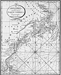 | Details | Malham, John | 1801 |
| A Correct Chart of the East Coast of North America 2nd. Ed. |
|
Malham, John |
|
| 1801 |
| LOC:0 |
| $0.00 | Malham--John | A-Correct-Chart-of-the-East-Coast-of-North-America-2nd--Ed- | SOLD
<br></br>
Antique small-scale copper-plate chart by John Malham. Coverage includes from the North Coast of Cuba, Florida and Bahamas past the Grand Bank to Labrador. Both latitude and longitude are clearly marked as well as numerous rhumb lines. Direction of prevailing current flow of the "Florida Stream" is shown by arrows. This later 1801 version of Malham's 1796 chart includes the label "St. Georges Bank, for that well-known fishing area, a feature missing from the earlier chart.
<br></br>
Rev. John Malham was a prolific Yorkshire-born author. Malham died near London in 1807. (Gentleman's Magazine, Vol 102, 1807, p. 568). |
| 80 | 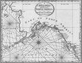 | Details | Malham, John | 1801 |
| A Correct Chart of the West Coast of North America |
|
Malham, John |
|
| 1801 |
| LOC:3 |
| $350.00 | Malham--John | A-Correct-Chart-of-the-West-Coast-of-North-America | Crisp antique copperplate map / chart of Alaska published from Boston in 1801 by Rev. John Malham in Malham's Naval Gazetteer. One of the earliest available maps of Alaska printed in the United States in the early 19th century. Named features include Bristol Bay, Prince William's Sound, Queen Charlotte's Isles, Mt. St. Elias, Cook's River, Bhering's Straits, Port Bukarelli (Bucareli Bay), and Kodiak Island.
<br></br>
The land mass that today we call Alaska is only noted as "Part of North America", and the designation "Alaska" is reserved for the Alaska Peninsula, a narrow body of land separating Bristol Bay from the Pacific Ocean.
<br></br>
This later edition of Malham's map is updated with detailed place names not found in his earlier map of 1796. Mt. St. Elias, today designated Boundary Peak 186, is much more prominently noted. Numerous decorative rhumb lines.
<br></br>
Rev. John Malham was a prolific Yorkshire-born author. Malham died near London in 1807. (Gentleman's Magazine, Vol 102, 1807, p. 568). |