| | Thumbnail | | Creator | Date | Title / Author / Date / Location | Price | | | Description |
| 6417 | 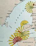 | Details | Marine Board of South Australia | 1885 |
| Lighthouse Map of the Province of South Australia Rare Chart |
|
Marine Board of South Australia |
|
| 1885 |
| LOC: |
| $2,195.00 | Marine-Board-of-South-Australia | Lighthouse-Map-of-the-Province-of-South-Australia-Rare-Chart | A fine, unrecorded edition of the Lighthouse Map of the Province of South Australia January 1, 1885 published by the Marine Board of South Australia, Thomas N. Stevens, Secretary. Inset maps showing light beacons for Port Adelaide River and Port Pirie River. "The Marine Board was responsible for shipping safety, buoys, lighthouses and explosives amongst other functions." [1]
<br><br>
Large format charts of lighthouses displaying graphically the light color, period, and distance visible are very rare. See [2], [3]. For Australia this is the only copy recorded of this map for the 1885 edition. Only three other editions with one copy each (1881, 1883, and 1885) are held in Australian institutions. No copy of the 1885 edition is found anywhere online nor are any sales recorded in AMPR for any copy of this Australian Lighthouse Map.
<br><br>
P.P. No. 43. Lithographed by E. Spiller, Government Printer, Adelaide.
<br><br>
Inset index tables: (1) Reference to Lights with the lighthouse name, color, distance visible, period and other key data for each lighthouse. (2) List of Government Wharves and Jetties Showing Length and Depth of Water at Low Water.
<br><br>
Coverage of this Australian lighthouse chart stretches from Waterloo Bay at the west to Cape Northumberland at the south east. Includes the waters of Spencer Gulf, Separator Strait, Kangaroo Island, and the Gulf of St. Vincent with Port Adelaide.
<br><br>
[1] Encyclopedia of Australian Science. Online: https://www.eoas.info/biogs/P006561b.htm. <br>
[2] BRITISH LIGHTHOUSE CHART OF GENERAL COAST LIGHTS. Compiled from authentic sources by Woolfield H. F. Hardinge. London: J. D. Potter Admiralty Chart Agent, 1874.[3] <br>
[3] A Chart exhibiting the Light Houses and Light Vessels of the Coasts of Great Britain and Ireland and also those on the N.W. coasts of Europe between Ushant and Bergen. Alexander G. Findlay. London. Corporation of Trinity House. Published by R. H. Laurie. 1863. |