| | Thumbnail | | Creator | Date | Title / Author / Date / Location | Price | | | Description |
| 643 | 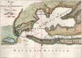 | Details | Masi, Tommaso Gio. | 1763 |
| Piano del Porto e degli Stabilimenti di Pensacola. |
|
Masi, Tommaso Gio. |
|
| 1763 |
| LOC:0 |
| $0.00 | Masi--Tommaso-Gio- | Piano-del-Porto-e-degli-Stabilimenti-di-Pensacola- | SOLD
<br></br>
Beautifully engraved antique plan of Pensacola, Florida. |
| 3584 | 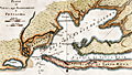 | Details | Masi, Tommaso Gio. | 1763 |
| Piano del Porto e degli Stabilimenti di Pensacola by Masi |
|
Masi, Tommaso Gio. |
|
| 1763 |
| LOC:200 |
| $0.00 | Masi--Tommaso-Gio- | Piano-del-Porto-e-degli-Stabilimenti-di-Pensacola-by-Masi | SOLD <br><br>
Beautifully engraved antique plan of Pensacola, Florida and the surrounding bays and sounds created in 1763 when Pensacola was not much more than a tiny village. Coverage includes areas of present day Gulf Islands National Seashore, Gulf Breeze, Pensacola Beach, Navarre, Navarre Beach, Blackwater Bay, Escambia Bay, Santa Rosa Sound and Santa Rosa Island.
<br></br>
Two old forts are noted, Fort Santa Rosa, a long-destroyed log fort built by the Spanish on the western end of Santa Rosa Island near present day Fort Pickens, and Fort Santa Maria de Galres (Galves/Galve) , near present day Fort Barrancas. Other features noted that reflect Spanish/Italian place names are "Baia di Santa Maria de Galres" - Pensacola Bay; "Golfo dell Ostriche", now Escambia Bay; "Canale di Santa Rosa" or Santa Rosa Sound; "Fiume del Governatore" and "Fiume del Almirante" - the Yellow and Blackwater Rivers. Siguenca Point at the western tip of Santa Rosa Island is named after Dr. Carlos de Siguenza y Gongora, a member of a Spanish reconnaissance expedition in 1693 who was one of the first to map Pensacola Bay.
<br></br>
Originally published in the Gazzetiere Americano, from Livorno, Italy. Contains many soundings and notations of the composition of the sea bottom, important to navigators who had to rely heavily on lead-line measurements for safe passage. Engraved by Giusepe Pazzi and drawn by Viol. Vanni. |
| 5177 |  | Details | Masi, Tommaso Gio. | 1763 |
| Piano del Porto e degli Stabilimenti di Pensacola Uncolored |
|
Masi, Tommaso Gio. |
|
| 1763 |
| LOC:87 |
| $575.00 | Masi--Tommaso-Gio- | Piano-del-Porto-e-degli-Stabilimenti-di-Pensacola-Uncolored | Beautifully engraved antique plan of Pensacola, Florida and the surrounding bays and sounds created in 1763 when Pensacola was not much more than a tiny village. Coverage includes areas of present day Gulf Islands National Seashore, Gulf Breeze, Pensacola Beach, Navarre, Navarre Beach, Blackwater Bay, Escambia Bay, Santa Rosa Sound and Santa Rosa Island.
<br></br>
Two old forts are noted, Fort Santa Rosa, a long-destroyed log fort built by the Spanish on the western end of Santa Rosa Island near present day Fort Pickens, and Fort Santa Maria de Galres (Galves/Galve) , near present day Fort Barrancas. Other features noted that reflect Spanish/Italian place names are "Baia di Santa Maria de Galres" - Pensacola Bay; "Golfo dell Ostriche", now Escambia Bay; "Canale di Santa Rosa" or Santa Rosa Sound; "Fiume del Governatore" and "Fiume del Almirante" - the Yellow and Blackwater Rivers. Siguenca Point at the western tip of Santa Rosa Island is named after Dr. Carlos de Siguenza y Gongora, a member of a Spanish reconnaissance expedition in 1693 who was one of the first to map Pensacola Bay.
<br></br>
Originally published in the Gazzetiere Americano, from Livorno, Italy. Contains many soundings and notations of the composition of the sea bottom, important to navigators who had to rely heavily on lead-line measurements for safe passage. Engraved by Giuseppe Pazzi and drawn by Viol. Vanni. |
| 3657 | 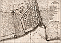 | Details | Masi, Tommaso Gio. | 1763 |
| Plan of the walled city of Santo Domingo. |
|
Masi, Tommaso Gio. |
|
| 1763 |
| LOC:77 |
| $350.00 | Masi--Tommaso-Gio- | Plan-of-the-walled-city-of-Santo-Domingo- | Scarce engraved antique nautical plan (after Thomas Jefferys) of the walled town of Santo Domingo on the island of Hispaniola. With a legend explaining numerous important locations on the plan including Fort San Girolamo, the Cathedral, and the Palace of Christopher Columbus (Cristoforo Colombo). Includes the bar across the entrance to the Ozama River as well as suggested anchorages within the river. Details on roads surpasses what is typical for nautical plans of this era. Italian text.
<br></br>
Originally published in the Gazzetiere Americano, from Livorno, Italy. Contains a few depth soundings and notations of the composition of the sea bottom, important to navigators who had to rely heavily on lead-line measurements for safe passage. Engraved by Giuseppe Pazzi and drawn by Viol. Vanni. |
| 642 | 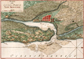 | Details | Masi, Tommaso Gio. | 1763 |
| Piano della Citta e Porto di Sant Agostino |
|
Masi, Tommaso Gio. |
|
| 1763 |
| LOC:200 |
| $625.00 | Masi--Tommaso-Gio- | Piano-della-Citta-e-Porto-di-Sant-Agostino | Handsome, pre-revolutionary war (1763) Italian antique copperplate engraved plan of the old town and port of St. Augustine, Florida. Areas and features named on the plan include the Matanzas River, San Marco River, San Sebastian River, Anastasia Island, Castillo de San Marcos ( oldest fort in the U.S.) , and Fort Picolata, built by the Spaniards to protect a ferry landing.
<br></br>
Nicely preserved specimen of one of the earliest available plans of Saint Augustine, the oldest continuously inhabited European settlement in the United States. St. Augustine is depicted with a neatly laid out network of perpendicular streets and surrounded by a high wall with several bastions. On the North and South ends and outside of the walled city are noted "Citta Indiana" or American Indian habitations. Numerous soundings and depictions of sandbanks and other hazards surround the entrance to the port.
<br></br>
The landing place of General James Oglethorpe is identified at the left end of the coastline (Sbarco del Gen. Oglethorpe). The General landed at that spot with an English force in 1740 during the War of Jenkin's Ear.
<br></br>
Originally published in the Gazzetiere Americano, from Livorno, Italy. Engraved by Guiseppe Pazzi and drawn by Viol. Vanni. |