| | Thumbnail | | Creator | Date | Title / Author / Date / Location | Price | | | Description |
| 8039 | 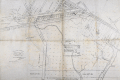 | Details | Mason, W.A. | 1887 |
| Unrecorded Manuscript Trace Cambridgeport Lands Frederick Lothrop Ames |
|
Mason, W.A. |
|
| 1887 |
| LOC:1401 |
| $2,750.00 | Mason--W-A- | Unrecorded-Manuscript-Trace-Cambridgeport-Lands-Frederick-Lothrop-Ames | A large, unrecorded pen and ink trace map on tracing cloth depicting lands on the Charles River Flats then held by the estate of Frederick Lothrop Ames (1) and associated owners, on the site now occupied by the Massachusetts Institute of Technology. The map was copied by William H. Whitney after Mason in the same month that the Massachusetts Legislature passed legislation that forced the cities of Cambridge and Boston to build the Harvard Bridge and share costs (2). Some portion of the map is attributed in pencil to a blueprint in Ames' possession, likely by W. A. Mason. Verso with the oval blue ink overstamp of William H. Whitney and index number 313.
<br><br>
The map was prepared in 1887, at a moment when the Charles River Embankment Company had begun construction of its granite seawall and was actively filling the Charles River Flats with dredged material from the river. It shows significant detail of the hydrography of the area including height in feet above low water at spring tide and the course of several small waterways including a detailed survey of Goff's Cove.
<br><br>Using the west line of the proposed Main Street extension, later realized as the Harvard Bridge, as a fixed boundary, and reading the notation on the mapped boundary, it appears Ames had already deeded lands west of this line to the Embankment Company. This drawing would have served as the working basis for negotiations over the remaining eastern portion of the Flats still under his ownership.
<br><br>
The sheet approximately covers the Charles River Flats from the navigable canal on the east to Goff's Cove on the west, and from the Boston and Albany Branch Railroad south to the planned 200 foot parkway along the riverbank. Detailed annotations at center record precise parcel boundaries totaling more than 2.3 million square feet and specify the fractional ownership interests of four parties, including Ames and the Charles River Embankment Company. Scale 80 feet to 1 inch.
<br><br> |