| | Thumbnail | | Creator | Date | Title / Author / Date / Location | Price | | | Description |
| 6597 | 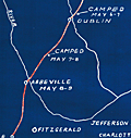 | Details | McClelland S.W. Kincaid R.L. et al | 1941 |
| Cyanotype (blueprint) map of the Route of Jefferson Davis in Spring 1865 |
|
McClelland S.W. Kincaid R.L. et al |
|
| 1941 |
| LOC:3 |
| $200.00 | McClelland-S-W--Kincaid-R-L--et-al | Cyanotype-(blueprint)-map-of-the-Route-of-Jefferson-Davis-in-Spring-1865 | Unrecorded and interesting cyanotype map of the route of Confederate General Jefferson Davis as he fled south after the Civil War from Charlotte, North Carolina to the city of Irwinville, Georgia where he hoped to escape to a foreign country. The map shows key rivers crossed and locations where Jefferson Davis stopped along the route.
<br><br>
Creators were Dr. S.W. McClelland, Dr. R.L. Kincaid, Dr. J.M. Nicholson, and C.P. Williams in August. 1941. This blueprint map is yet another scarce example of how an early photographic reproduction technology allowed individuals to disseminate their own unique works, bypassing traditional publishing technologies and institutions. |