| | Thumbnail | | Creator | Date | Title / Author / Date / Location | Price | | | Description |
| 7980 | 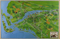 | Details | Metropolitan Fort Meyers Chamber of Commerce | 1975 |
| Pictorial Map of Fort Meyers Florida |
|
Metropolitan Fort Meyers Chamber of Commerce |
|
| 1975 |
| LOC:130 |
| $250.00 | Metropolitan-Fort-Meyers-Chamber-of-Commerce | Pictorial-Map-of-Fort-Meyers-Florida | Pictorial Map of Fort Meyers, Florida. A brightly colored illustrated guide showing the Fort Myers area and nearby islands (Sanibel, Captiva, and Estero Island) extending westward to the Gulf of Mexico and eastward past Lehigh Acres. The Caloosahatchee River flows prominently through the center. Rather than a strict topographic depiction, it’s designed for tourist orientation, highlighting motels, attractions, farms, and local roads.
<br><br>
Verso with black and white advertisements for local businesses. Based on the businesses advertised ChatGPT estimates the age of the map from the early to the mid 1970's era.
<br><br> Published by the Metropolitan Fort Meyers Chamber of Commerce. |