| | Thumbnail | | Creator | Date | Title / Author / Date / Location | Price | | | Description |
| 5399 | 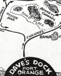 | Details | Michaels, Lawrence | 1947 |
| Map of the Halifax River Port Orange Florida Dave's Dock |
|
Michaels, Lawrence |
|
| 1947 |
| LOC:11 |
| $195.00 | Michaels--Lawrence | Map-of-the-Halifax-River-Port-Orange-Florida-Dave-s-Dock | Rare map of the Halifax River area near Port Orange, Florida ca. 1947. The map is on the verso of a folding postal card featuring Dave's Dock (currently Aunt Catfish's since ca. 1979), about five miles south of Daytona, Florida. Unfolds to 3.5" x 11".
<br></br>
In addition to channels and fishing areas, noted features on the chart include:
<div class="indenttextblocksingle">
<ul style="list-style-type: circle;">
<li>Location of the old Port Orange Bridge.</li>
<li>Pelican Island</li>
<li>Freeman Oyster bar</li>
<li>Rose Bay</li>
<li>Wilbur Bay</li>
<li>Daggett's Island</li>
<li>Peter Johnson's Point</li>
<li>Fozzard, Sutton, Sharpe's and Mill's Creeks</li>
<li>Half Dollar Island</li>
</ul>
</div>
Dave’s Dock was built before 1938. Lawrence “Mike” Michaels, bought Dave’s Dock in the mid 1940's and retained ownership until 1959. Front of the card shows fishing and pleasure boats tied up at Dave's 600' long dock and a Coca Cola sign on the front of the office.
<br></br>
Name the owner was modified to read " L. Michaels" on the camera-ready copy by a quick 'copy and paste' before printing. That must mean that this is a second edition of Dave's Dock card. The scene shown may reflect a much earlier date, perhaps as early as 1938 when the dock was first built. |