| 704 | 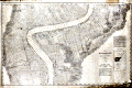 | Details | Mississippi River Commission | 1894 |
| The Mississippi River near St. James, Louisiana |
|
Mississippi River Commission |
|
| 1894 |
| LOC:0 |
| $450.00 | Mississippi-River-Commission | The-Mississippi-River-near-St--James--Louisiana | Large, very scarce, rolled survey chart or map of the Brilliant Point and College Point portions of the Mississippi River from 1894. Coverage on this antique map stretches across St. James Parish and documents numerous plantations, cultivated fields, and individual land holdings, including many with French surnames: Bonnecaze, Dernier, Bourgeois, Braud, Fabre, and Plaisance.
<br></br>
An inset index chart identifies the area as belonging to the Brilliant Point and College Point stretches of the Mississippi River, but may be more familiar as that portion of the river between Baton Rouge and New Orleans that includes the area near St. James, Louisiana and Oak Alley Plantation. No copy of this chart or any from the series are currently known to be available for sale.
<br></br>
On the North bank of the Mississippi are 3 towns: College, Donnelson, Wilton, and Hester; a race track, Jefferson College, and Sacred Heart Convent, Numerous plantations are mapped including St. Belmont Plantation, Homestead Plantation, Oneida Plantation, Uncle Sam Plantation, Wilton Plantation, Helvetia Plantation, St. Rose Plantation, St. Michael Plantation.
<br></br>
On the river's South bank lies St. Emma and a settlement referred to as "Free Town". Identified plantations on the South bank include Oak Alley Plantation, St. James Estate, Felicite Plantation, St Joseph Plantation, Home Place Plantation, Jefferson Plantation, Pikes Peak Plantation, Cabanocey Plantation, Rich Bend Plantation, Bonsecour Plantation, M.B.C. Plantation, St. Cecile Plantation, Sydney Plantation, La Pice Plantation, and St. Claire Plantation.
<br></br>
Photo lithograph produced by Julius Bien and Company. From a two volume set of 78 sheets produced by the Mississippi River Commission ca. 1896 . Detailed soundings from bank to bank at approximately 400 - 500 foot intervals. Railroads and numerous benchmarks are identified. Number 71. |