| | Thumbnail | | Creator | Date | Title / Author / Date / Location | Price | | | Description |
| 1198 | 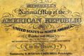 | Details | Mitchell, Samuel Augustus | 1843 |
| Mitchell's National Map of the American Republic first ed. |
|
Mitchell, Samuel Augustus |
|
| 1843 |
| LOC:0 |
| $1,400.00 | Mitchell--Samuel-Augustus | Mitchell-s-National-Map-of-the-American-Republic-first-ed- | Large 1st edition linen-backed hanging map of the eastern United States surrounded with insets of the vicinity of major towns, ports, and harbors. This scarce map features 32 colored insets of United States cites including New Orleans, St. Louis, Nashville, Natchez, Mobile, Savannah, Charleston, Raleigh and many more. Population tables for each county in the different states and territories in 1840. Eastern Kansas and Oklahoma are shown combined and is labeled "Indian Territory" with tribes identified including Omaha's, Kickapoos, Cherokee, and Shawnee. Large Iowa Territory. Minnesota is not yet named foreshadowing the Westward population expansion to follow in later decades.
<br></br>
With an inset map of the Treaty of 1842, also called Webster-Ashburton Treaty settling a border dispute between Maine and New Brunswick.
<br></br>
Samuel Augustus Mitchell Sr. (1792-1868) is one of the pioneers in American cartography of the 19th century and led the conversion of engraved map plates to more affordable lithographic plates. Drawn by James Henry Young (1817-1866) and engraved by J.H. Brightly, both collaborated with Mitchell on this series of maps. Published from 8 1/2 South Seventh Street, Philadelphia. Wall map on linen with wooden scrolls. |
| 1426 | 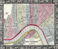 | Details | Mitchell, Samuel Augustus | 1860 |
| Antebellum Map of New Orleans, Louisiana |
|
Mitchell, Samuel Augustus |
|
| 1860 |
| LOC:0 |
| $0.00 | Mitchell--Samuel-Augustus | Antebellum-Map-of-New-Orleans--Louisiana | NOT AVAILABLE
<br></br>
Attractive antique map from 1860 of New Orleans, Louisiana with 11 of its 17 wards. On the West Bank of the Mississippi River three early neighborhoods are identified by their old (current) name: Algiers (Algiers Point); MacDonough (McDonogh), and Belle Ville (Whitney). Most of the boundaries of Wards 1 through 11 were drawn in 1852 when the city was reorganized into one centralized political entity. <a href="https://en.wikipedia.org/wiki/Wards_of_New_Orleans" target="_blank">Online. </a>
<br></br>
This neat, colorful old map clearly shows several early canals which evolved for both drainage and transport over a long period. For example the Carondelet Canal or Old Basin Canal, was a canal in New Orleans, operating for almost 135 years- from 1794 into the 1920s. The canal started at Bayou St. John, which connected with Lake Pontchartrain, and went inland to what was then the back edge of New Orleans, in the Tremé neighborhood. The two-acre turning basin at the head of the Canal inspired the naming of Basin Street in New Orleans.
<br></br>
Attribution at bottom reads: Entered according to Act of Congress, in the year 1860 by S. Augustus Mitchell Jr. in the clerks office of the District Court of the U.S. for the eartern District of Pennsylvania. Number 33.
<br></br>
Samuel Augustus Mitchell Sr. (1792-1868) is one of the pioneers in American cartography of the 19th century and led the conversion of engraved map plates to more affordable lithographic plates. |