| | Thumbnail | | Creator | Date | Title / Author / Date / Location | Price | | | Description |
| 5205 | 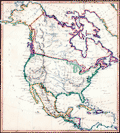 | Details | Morris | 1850 |
| Manuscript Map of North America |
|
Morris |
|
| 1850 |
| LOC:3 |
| $300.00 | Morris | Manuscript-Map-of-North-America | Fascinating antique manuscript map of North America, ca. 1850 by "Morris". Carefully drawn and lettered, this map clearly reflects the work of a dedicated draughtsman with fine penmanship at a very small size. It is difficult to imagine that anyone would be able to work in finer detail than on this small map.
<br></br>
Among the named features, a few help narrow the date when the map was drawn:
<div class="indenttextblocksingle">
<ul style="list-style-type: circle;">
<li>Shows the old West Florida Territory extending westward into Louisiana suggesting a date for the map between 1822 and 1845.</li>
<li>Shows Alaska as "Russian America" a term applied between 1733 and 1867 when Russia sold the Russian colony to the United States of America.</li>
<li>Shows Milledgeville, Georgia, the capital of that state from 1804 to 1868.</li>
<li>The map shows the boundaries of the New Mexico Territory, established in 1850</li>
</ul>
</div> |