| | Thumbnail | | Creator | Date | Title / Author / Date / Location | Price | | | Description |
| 1067 | 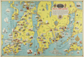 | Details | Mount Hope Bridge Corporation | 1937 |
| 1937 Pictorial Map of Newport, RI and Ten Mile Drive |
|
Mount Hope Bridge Corporation |
|
| 1937 |
| LOC:0 |
| $0.00 | Mount-Hope-Bridge-Corporation | 1937-Pictorial-Map-of-Newport--RI-and-Ten-Mile-Drive | SOLD
<br></br>
Charming pictorial maps of the topography, key features, and residences around Narragansett Bay, the Sakonet River, Buzzards Bay and Vineyard sound, on front and back of a folding pamphlet. Folds into a compact 4.5" x 9". Six vertical folds and one horizontal fold, as issued.
<br></br>
Consists of 4 maps total plus a description of the area and a title page. Two significant maps are of most interest:
<ul>
<li style="margin:2em; list-style-type: circle; line-height: 1.2em;">The largest map, a full 25" x 17", shows numerous points of interest in and near Newport, Portsmouth, Tiverton and Bristol, RI; New Bedford, Dartmouth, Onset, Bourne, and Falmouth, MA with Martha's Vineyard at bottom right.</li>
<li style="margin:2em; list-style-type: circle; line-height: 1.2em;">On the verso, a half-page detailed map of the 10-mile drive titled: "Newport's Famous Ten Mile Drive Along the Oceanfront" shows the "beautiful summer residences of many prominent people". Coverage includes Aquidneck Island with Newport and Portsmouth.</li>
</ul>
Arranged by historian John W. Haley and designed by H.W. Hetherington of Newport Rhode Island. The lithograph was published by the J.C. Hall Company of Providence, RI. Copyright 1937 by Mount Hope Bridge Corporation. |