| | Thumbnail | | Creator | Date | Title / Author / Date / Location | Price | | | Description |
| 3629 | 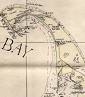 | Details | Nickerson, K.F. | 1955 |
| Manuscript chart of Cape Cod, Massachusetts Bay, Provincetown |
|
Nickerson, K.F. |
|
| 1955 |
| LOC:200 |
| $450.00 | Nickerson--K-F- | Manuscript-chart-of-Cape-Cod--Massachusetts-Bay--Provincetown | An interesting manuscript chart of Cape Cod and Cape Cod Bay in black and red ink. Not only does the chart have a different look than a printed chart but the item raises questions as to why so much care was placed on its creation. Signed by K.F. Nickerson and dated to February 1955.
<br></br>
Detailed mid 20th-century manuscript chart of Cape Cod, Massachusetts Bay and Cape Cod Bay. The MS chart is drawn on the verso of an earlier chart from 1935. Nickerson apparently cannibalized an old chart simply to create his chart on the back. We don't know why Nickerson spent so much time on the chart but it is evident he spent hours meticulously copying from an unknown source. Perhaps the map was constructed for sale as a tourist keepsake. More likely it had some utility to Nickerson in his occupation, because the chart detail is at a granular level that could be used for navigation.
<br></br>
Contains info on radio beacons, depth soundings, maritime hazards, aids to navigation and much more. Scale 1/2 inch = 1 mile. |