| | Thumbnail | | Creator | Date | Title / Author / Date / Location | Price | | | Description |
| 3610 | 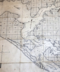 | Details | O'Neal, Robert | 1887 |
| Unusual antique cadastral map of St. Andrews Bay, Florida |
|
O'Neal, Robert |
|
| 1887 |
| LOC:0 |
| $0.00 | O-Neal--Robert | Unusual-antique-cadastral-map-of-St--Andrews-Bay--Florida | SOLD<br></br>
Early, scarce cadastral map of St. Andrews Bay and lands owned by the St. Andrews Bay Rail Road and Land Company. Florida related. Noted features include Spanish Shanty Point, two mills, a hotel, Redfish Point, Pearl Bayou, Laughton's Bayou, Grand Lagoon, Hurricane Isle, and a "Road to Chipley".
<br></br>
A report by Pamela Brown for the University of Florida’s Soil and Water Department notes:
<div class="indenttextblock">
"A Cincinnati mail-order company, the Saint Andrew Bay Railroad, Lands, and Mining Co., bought property in the Saint Andrew Bay area, and started nationally advertising 25 feet x 82 feet lots for $1.25. The advertisement attracted a lot of people and started a settlement boom as over 300,000 lots were sold. As the price for lots increased to $8.00, the company went bust." <a href="https://soils.ifas.ufl.edu/media/soilsifasufledu/sws-main-site/pdf/technical-papers/Brown--Pamela-Sue.pdf" target="_blank">Online, p. 46)</a>
</div>
</br>
Oyster bars shown with " |||| " symbols. Additional manuscript compass rose. Scale 1 inch = 1 mile. Copyrighted by Robert O'Neal May 27th, 1887.
<br></br>
Map is accompanied with an early Warranty Deed issued by the St. Andrews Bay Railroad, Land, and Mining Co. in 1877 for a lot in a specified Block, Township, and Range on the map. Price for the lot in 1887 was $1.25. |