| | Thumbnail | | Creator | Date | Title / Author / Date / Location | Price | | | Description |
| 5186 | 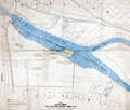 | Details | Oakland Waterfront Company | 1916 |
| Map of a Portion of Oakland Harbor and Alameda Encinal Basin |
|
Oakland Waterfront Company |
|
| 1916 |
| LOC:63 |
| $1,850.00 | Oakland-Waterfront-Company | Map-of-a-Portion-of-Oakland-Harbor-and-Alameda-Encinal-Basin | Large original map and engineering drawing of the area surrounding Alameda's present-day Star Harbor re-development project. The map, with <b>numerous manuscript notations</b>, shows a portion of Oakland Harbor related to the contract for dredging in the area of what is now the Marina Village Yacht Harbor in Alameda, California. Toward the bottom the map clearly shows a <b>"line segregating high-and-dry land from marsh land."</b>
<br></br>
<img src="/ZoomifyImages/SC_5186/SC_5186_Context.jpg" alt="Context map for the Oakland Harbor map of 1916" width="320" align="center" style="margin: 0px 20px">
<br></br>
</br>
This map was made in 1916 in the first decade after the City of Oakland took ownership of the waterfront (1907) after almost 50 years of private ownership by the Oakland Waterfront Company. The map shows Oakland Harbor from Webster Street with the Webster Street Bridge (1871-1928) and the Harrison Street Bridge (1898-1924) for the Southern Pacific Railroad; the western portion of Coast Guard Island, and those portions of Oakland and Alameda lying to the east just past Fortman Basin.
<br></br>
Oakland, California has a long history as an important transportation hub. Oakland was the western terminus for the Southern Pacific Railroad. Just east of the dredged area are the lands of the Alaska Packer's Association where, by 1925, the Encinal Basin was dredged for the use of cargo ships by what was to later become the Del Monte company.
<br></br>
Blueline base map with manuscript notations in red and green with hand-applied wash coloring. Dated within to 1916. Compiled by R.E. Demeritt, C.E.
<br></br>
Manuscript notations include engineering calculations and this statement: "
<b>"Duplicate of this map delivered to Harrison S. Robinson January 28, 1919. Geo Sessions."</b>
Harrison S. Robinson was an attorney in Oakland, California; George L. Sessions from Sessions Waterfront Company. |