| | Thumbnail | | Creator | Date | Title / Author / Date / Location | Price | | | Description |
| 6634 | 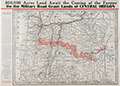 | Details | Oregon and Western Colonization Company | 1911 |
| Oregon military road land grant map |
|
Oregon and Western Colonization Company |
|
| 1911 |
| LOC:53 |
| $0.00 | Oregon-and-Western-Colonization-Company | Oregon-military-road-land-grant-map | SOLD
<br><br>
Lithographed map of Oregon grant lands featuring land grants available to settlers. Issued in 1911 as an advertising/marketing publication by the Oregon and Western Colonization Company, St. Paul, Minnesota. Scarce map. Shows several railroad lines including the Oregon Trunk Railway, Great Northern Railway, and the Oregon Electric Railway.
<br><br>
The Washington State University library concisely summarizes the history of this Military Road Land Grant:
<div class="indenttextblocksingle">
"A group of pioneers bent on constructing an east-west military wagon road across Oregon were, in 1866, awarded land grants consisting of alternate sections of land within six miles on either side of their road. The Santiam Wagon Road, as it became known, was reported finished in 1868 and opened that year as a toll road. After the grant lands passed through several hands, the Oregon & Western Colonization Co. purchased the rights to this land in 1908, and began selling the land shortly thereafter." (1) </div>
<br>
Dated within 3-11-11. Number 5307.
<br><br>
The area of the land grants include the summit of an extinct volcano- Three Fingered Jack and the towns of:
<div class="indenttextblocksingle">
<ul style="list-style-type: circle;">
<li>Lebanon, </li>
<li>Sisters,</li>
<li>Prineville</li>
<li>Paulina,</li>
<li>Burns, and</li>
<li>Skullspring.</li>
</ul>
</div>
(1) Online. Washington State University. https://content.libraries.wsu.edu/digital/collection/maps/id/659/
Accessed (January, 2023). |