| | Thumbnail | | Creator | Date | Title / Author / Date / Location | Price | | | Description |
| 5431 | 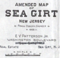 | Details | Osborn, Frank | 1909 |
| Plat sales map of Sea Girt New Jersey Atlantic Ocean |
|
Osborn, Frank |
|
| 1909 |
| LOC:90 |
| $125.00 | Osborn--Frank | Plat-sales-map-of-Sea-Girt-New-Jersey-Atlantic-Ocean | Original lithographed plat map of Sea Girt, New Jersey in Monmouth County by Frank Osborn. The maps reflects sales of residential lots as early as 1909 but the Borough of Sea Girt was formed by an act of the New Jersey Legislature later, in March, 1917.
<br></br>
The features depicted on the map include the state military encampment including a "Governor's Cottage"; Crescent Park, Edgemere Park, Sea Girt Inlet and the Sea Girt Station- apparently used by several railroads including the New York and Long Branch Railroad. Also shows the route for a trolley line snaking through the settlement to other N.J. communities including Spring Lake, Belmar, Ocean Grove, and Asbury Park.
<br></br>
Title includes the name of the real estate agent selling the property: E.V. Patterson Jr. on Washington Boulevard in Sea Girt NJ. Interestingly, the map does not show the Sea Girt Lighthouse which has occupied a corner at Ocean Avenue and Beacon Boulevard since 1896.
<br></br>
North is oriented to the upper right. |