| | Thumbnail | | Creator | Date | Title / Author / Date / Location | Price | | | Description |
| 3593 | 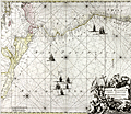 | Details | Ottens, Ranier and Joshua | 1745 |
| Spectacular antique chart of Mexico, Central America and South America |
|
Ottens, Ranier and Joshua |
|
| 1745 |
| LOC:51 |
| $1,150.00 | Ottens--Ranier-and-Joshua | Spectacular-antique-chart-of-Mexico--Central-America-and-South-America | Copper-engraved sea chart oriented with north to the left, showing the Pacific Ocean from Xalisco, Mexico, to Puerta Bairres in Chile (including Yucatan, Central America, the Western Caribbean and the Galapagos Islands). Columbia is shown in its entirety, along with a small piece of Venezuela. Includes well over 125 place names arranged in Portolan style. Finely engraved title cartouche with conquistadors, slaves, and putti set into an allegorical background.
<br></br>
Updated and corrected sea chart by Ottens, after Renard and de Wit from "Atlas van Zeevart en Koophandel door de Geheele Wereldt" (Amsterdam, 1745). The name of Louis Renard has been replaced by the names of Reinier and Joshua Ottens. Reinier and Joshua Ottens (1704-1765) were Dutch publishers, cartographers and map engravers. The family business was founded by their father Joachim, but the firm was most productive under the leadership of Reinier and Joshua. |