| | Thumbnail | | Creator | Date | Title / Author / Date / Location | Price | | | Description |
| 6806 | 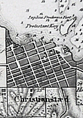 | Details | Oxholm, Peter Lotharius | 1799 |
| Rare antique map of the Caribbean island of St. Croix slavery |
|
Oxholm, Peter Lotharius |
|
| 1799 |
| LOC:2001 |
| $0.00 | Oxholm--Peter-Lotharius | Rare-antique-map-of-the-Caribbean-island-of-St--Croix-slavery | SOLD<br><br>Rare, highly detailed and accurate map of the Caribbean island of St. Croix by Peter Oxholm. Dated 1799 per the Royal Danish Library. Only two recorded copies in WorldCat, one at Bibliothèque nationale de France.
<br><br>
This second edition of Oxholm's map is updated with details for Christiansted Harbor after a survey by Captain Rohde. Table at top left in Danish and English with population statistics for Whites, Coloreds, and Negros. Denotes locations of the numerous windmills and horse-powered mills as well as cotton plantations ("bomulds plantage") on St. Croix. In spite of his strong advocacy for slavery Oxholm was concerned about poor living conditions of the slaves.
<br><br>
Dissected and laid to linen when issued. Library hand stamp from 1815 at top right. |