| | Thumbnail | | Creator | Date | Title / Author / Date / Location | Price | | | Description |
| 1096 | 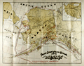 | Details | Pacific Steam Whaling Company | 1901 |
| Pacific Steam Whaling Company's Map of Alaska |
|
Pacific Steam Whaling Company |
|
| 1901 |
| LOC:0 |
| $0.00 | Pacific-Steam-Whaling-Company | Pacific-Steam-Whaling-Company-s-Map-of-Alaska | SOLD <br></br>
Antique map of Alaska featuring the routes of steamers, canneries, and whaling stations belonging to the <b>Pacific Steam Whaling Company</b>. The map served as a promotional tool for the firm with numerous notations (in red) designed to appeal to speculators and fortune seekers for example: "Gold", <b>"Gold Placer Diggings"</b>, "Gold and Copper Deposits", "Silver Ahead" and "Cape Nome Gold Field".
<br></br>
Published by the Pacific Steam Whaling Company, 30 California Street, San Francisco and Corner of 1st Ave and Yesler Way, Seattle.
<br></br>
According to the cover the coverage includes "Nome, Teller City, Behring City, Golofnin, Western Alaska, Cooks Inlet and Copper River gold diggings." Manuscript ink annotation with "Valdez" and a circle just below the town of Valdez.
<br></br>
Routes include the whaling steamer's route to Port Clarence,; the mail steamer's route to Cape Nome from Unalaska; routes to <b>Bristol Bay</b>, Prince William's Sound, and Seattle to Unalaska.
<br></br>
Folding map of Alaska unfolds to its full extent of 22" W x 17" H. |